Libby elevation
Libby (Montana, Lincoln County), United States elevation is 640 meters and Libby elevation in feet is 2100 ft above sea level [src 1]. Libby is a seat of a second-order administrative division (feature code) with elevation that is 361 meters (1184 ft) bigger than average city elevation in United States.
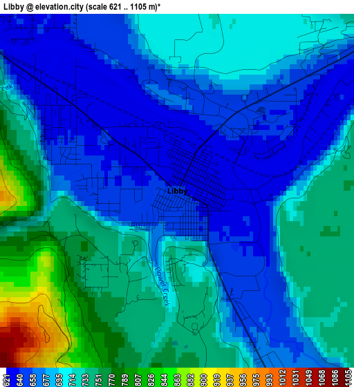
Below is the Elevation map of Libby, which displays elevation range with different colors. Scale of the first map is from 621 to 1105 m (2037 to 3625 ft) with average elevation of 702.4 meters (=2304 ft) [note 1]
These maps also provides idea of topography and contour of this city, they are displayed at different zoom levels. More info about maps, scale and edge coordinates you can find below images.
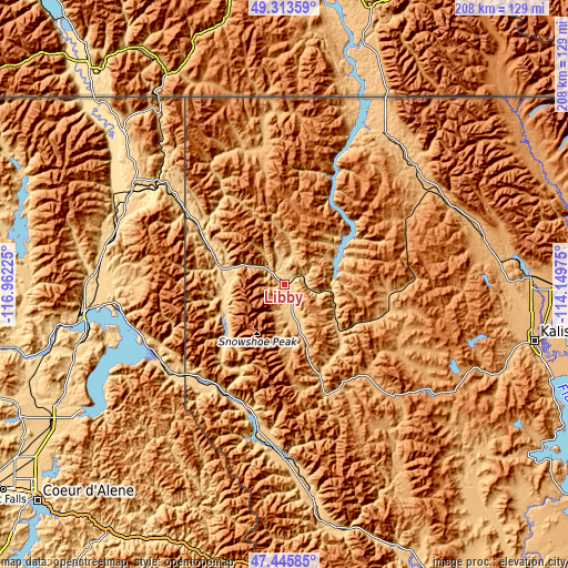
| \ | Map #1 | Topo.Map |
| Scale [m] | 621..1105 m | × |
| Scale [ft] | 2037..3625 ft | × |
| Average | 702.4 m = 2304 ft | × |
| Width | 6.49 km = 4 mi | 207.7 km = 129.1 mi |
| Height | 6.49 km = 4 mi | 207.7 km = 129.1 mi |
| ↑Max Latitude | 48.417465° | 49.31359° |
| Latitude at center | 48.38829° | 48.38829° |
| ↓Min Latitude | 48.359098° | 47.44585° |
| ← Min Longitude | -115.599945° | -116.96225° |
| Longitude center | -115.556° | -115.556° |
| →Max Longitude | -115.512055° | -114.14975° |
Nearby cities:
Cities around Libby sort by population:
• Kalispell elevation 904 m
94.4 km,  103°
103°
• Sandpoint 641 m
74.8 km,  260°
260°
• Evergreen 891 m
96.4 km, 100°
• Whitefish 928 m
90 km,  88°
88°
• Columbia Falls 938 m
101.5 km, 90°
• Bonners Ferry 580 m
65.3 km,  301°
301°
• Kellogg 703 m
103.4 km,  203°
203°
• Priest River 653 m
102.9 km, 257°
• Osburn 769 m
103.5 km, 198°
• Thompson Falls 759 m
89.7 km,  169°
169°
• Ponderay 650 m
72.8 km, 262°
• Eureka 786 m
66 km,  34°
34°
Multilingual:
 En español:
Libby elevación 640 m.
 En France:
Libby élévation 640 m.


Sources and notes:
- [note 1] Map square and city borders are not equal. Map elevation data is calculated only from area inside that square.
- [src 1] Elevation data from geonames database provided with same terms of usage.
- [src 2] The elevation map of Libby is generated using elevation data from NASA's 3 arcsec (90m) resolution SRTM data.
- [src 3] Base (background) map © OpenStreetMap contributors tiles are generated by Geofabrik and OpenTopoMap.
Copyright & License:
This Libby Elevation Map is licensed under CC BY-SA. You may reuse any part from this page, if you give a proper credit by linking to this URL:
 More info on terms of use page.