Sandpoint elevation
Sandpoint (Idaho, Bonner County), United States elevation is 641 meters and Sandpoint elevation in feet is 2103 ft above sea level [src 1]. Sandpoint is a seat of a second-order administrative division (feature code) with elevation that is 362 meters (1188 ft) bigger than average city elevation in United States.
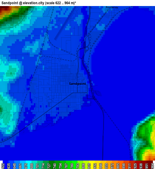
Below is the Elevation map of Sandpoint, which displays elevation range with different colors. Scale of the first map is from 622 to 964 m (2041 to 3163 ft) with average elevation of 644.2 meters (=2114 ft) [note 1]
These maps also provides idea of topography and contour of this city, they are displayed at different zoom levels. More info about maps, scale and edge coordinates you can find below images.
| \ | Map #1 | Map #2 | Topo.Map |
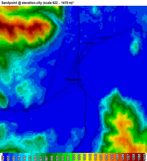
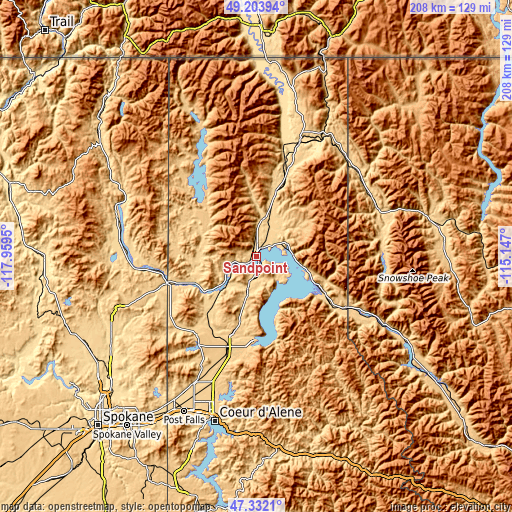
| Scale [m] | 622..964 m | 622..1419 m | × |
| Scale [ft] | 2041..3163 ft | 2041..4656 ft | × |
| Average | 644.2 m = 2114 ft | 744.7 m = 2443 ft | × |
| Width | 6.5 km = 4 mi | 13.01 km = 8.1 mi | 208.1 km = 129.3 mi |
| Height | 6.5 km = 4 mi | 13.01 km = 8.1 mi | 208.1 km = 129.3 mi |
| ↑Max Latitude | 48.305829° | 48.335051° | 49.20394° |
| Latitude at center | 48.27659° | 48.27659° | 48.27659° |
| ↓Min Latitude | 48.247334° | 48.218062° | 47.3321° |
| ← Min Longitude | -116.597195° | -116.641141° | -117.9595° |
| Longitude center | -116.55325° | -116.55325° | -116.55325° |
| →Max Longitude | -116.509305° | -116.465359° | -115.147° |
Nearby cities:
Cities around Sandpoint sort by population:
• Coeur d'Alene elevation 668 m
68.7 km,  194°
194°
• Post Falls 664 m
68.8 km,  205°
205°
• Hayden 697 m
59.4 km,  196°
196°
• Rathdrum 671 m
57.6 km, 206°
• Otis Orchards-East Farms 634 m
74.2 km, 211°
• Libby 640 m
74.8 km,  80°
80°
• Bonners Ferry 580 m
49.3 km,  20°
20°
• Dalton Gardens 690 m
62.9 km, 194°
• Newport 652 m
37.9 km,  253°
253°
• Spirit Lake 783 m
41.7 km, 214°
• Priest River 653 m
28.6 km, 248°
• Ponderay 650 m
3.5 km, 24°
Multilingual:
 En español:
Sandpoint elevación 641 m.
 En France:
Sandpoint élévation 641 m.
 Auf Deutsch:
Sandpoint höhe über dem Meeresspiegel ist 641 m.

Sources and notes:
- [note 1] Map square and city borders are not equal. Map elevation data is calculated only from area inside that square.
- [src 1] Elevation data from geonames database provided with same terms of usage.
- [src 2] The elevation map of Sandpoint is generated using elevation data from NASA's 3 arcsec (90m) resolution SRTM data.
- [src 3] Base (background) map © OpenStreetMap contributors tiles are generated by Geofabrik and OpenTopoMap.
Copyright & License:
This Sandpoint Elevation Map is licensed under CC BY-SA. You may reuse any part from this page, if you give a proper credit by linking to this URL:
 More info on terms of use page.