Pinehurst elevation
Pinehurst (Idaho, Shoshone County), United States elevation is 676 meters and Pinehurst elevation in feet is 2218 ft above sea level [src 1]. Pinehurst is a populated place (feature code) with elevation that is 397 meters (1302 ft) bigger than average city elevation in United States.
Below is the Elevation map of Pinehurst, which displays elevation range with different colors. Scale of the first map is from 652 to 1293 m (2139 to 4242 ft) with average elevation of 790.8 meters (=2594 ft) [note 1]
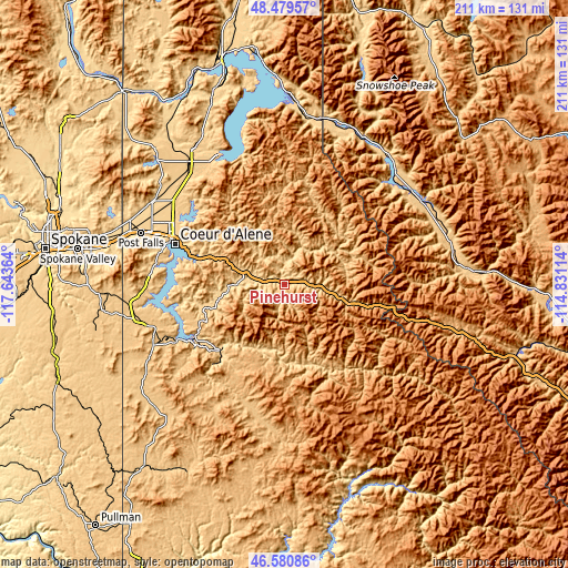
These maps also provides idea of topography and contour of this city, they are displayed at different zoom levels. More info about maps, scale and edge coordinates you can find below images.
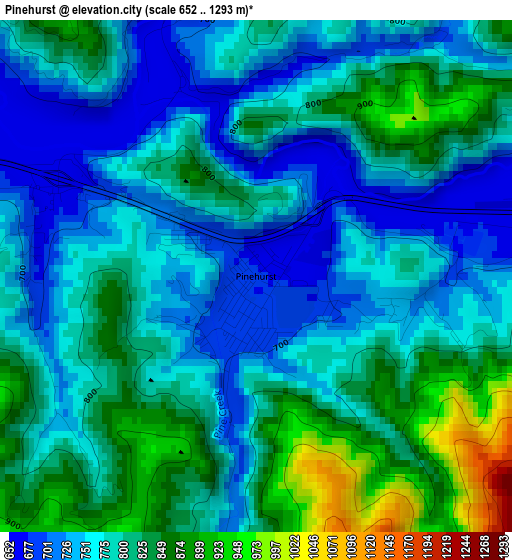
| \ | Map #1 | Topo.Map |
| Scale [m] | 652..1293 m | × |
| Scale [ft] | 2139..4242 ft | × |
| Average | 790.8 m = 2594 ft | × |
| Width | 6.6 km = 4.1 mi | 211.1 km = 131.2 mi |
| Height | 6.6 km = 4.1 mi | 211.1 km = 131.2 mi |
| ↑Max Latitude | 47.568469° | 48.47957° |
| Latitude at center | 47.53881° | 47.53881° |
| ↓Min Latitude | 47.509135° | 46.58086° |
| ← Min Longitude | -116.281335° | -117.64364° |
| Longitude center | -116.23739° | -116.23739° |
| →Max Longitude | -116.193445° | -114.83114° |
Nearby cities:
Cities around Pinehurst sort by population:
• Coeur d'Alene elevation 668 m
43.5 km,  290°
290°
• Post Falls 664 m
57.1 km, 290°
• Hayden 697 m
48.3 km,  301°
301°
• Rathdrum 671 m
58 km, 301°
• Otis Orchards-East Farms 634 m
65.9 km, 286°
• Saint Maries 667 m
35 km,  224°
224°
• Dalton Gardens 690 m
45.2 km, 297°
• Spirit Lake 783 m
67 km,  315°
315°
• Kellogg 703 m
8.9 km,  90°
90°
• Osburn 769 m
18.2 km,  101°
101°
• Plummer 830 m
54 km,  245°
245°
• Wallace 831 m
24.3 km,  107°
107°
Multilingual:
 En español:
Pinehurst elevación 676 m.
 En France:
Pinehurst élévation 676 m.
 Auf Deutsch:
Pinehurst höhe über dem Meeresspiegel ist 676 m.

Sources and notes:
- [note 1] Map square and city borders are not equal. Map elevation data is calculated only from area inside that square.
- [src 1] Elevation data from geonames database provided with same terms of usage.
- [src 2] The elevation map of Pinehurst is generated using elevation data from NASA's 3 arcsec (90m) resolution SRTM data.
- [src 3] Base (background) map © OpenStreetMap contributors tiles are generated by Geofabrik and OpenTopoMap.
Copyright & License:
This Pinehurst Elevation Map is licensed under CC BY-SA. You may reuse any part from this page, if you give a proper credit by linking to this URL:
 More info on terms of use page.