Polson elevation
Polson (Montana, Lake County), United States elevation is 892 meters and Polson elevation in feet is 2927 ft above sea level [src 1]. Polson is a seat of a second-order administrative division (feature code) with elevation that is 613 meters (2011 ft) bigger than average city elevation in United States.
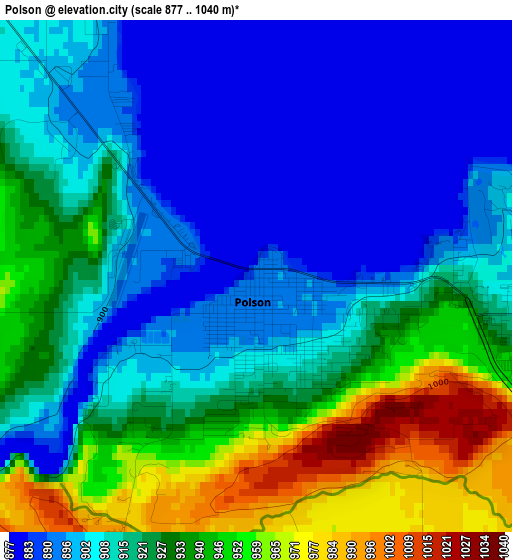
Below is the Elevation map of Polson, which displays elevation range with different colors. Scale of the first map is from 877 to 1040 m (2877 to 3412 ft) with average elevation of 919.2 meters (=3016 ft) [note 1]
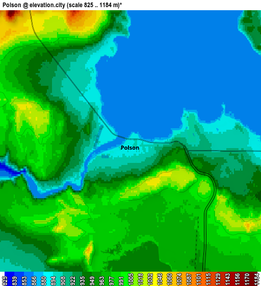
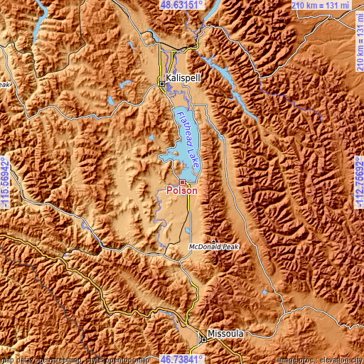
These maps also provides idea of topography and contour of this city, they are displayed at different zoom levels. More info about maps, scale and edge coordinates you can find below images.
| \ | Map #1 | Map #2 | Topo.Map |
| Scale [m] | 877..1040 m | 825..1184 m | × |
| Scale [ft] | 2877..3412 ft | 2707..3885 ft | × |
| Average | 919.2 m = 3016 ft | 940.2 m = 3085 ft | × |
| Width | 6.58 km = 4.1 mi | 13.16 km = 8.2 mi | 210.5 km = 130.8 mi |
| Height | 6.58 km = 4.1 mi | 13.16 km = 8.2 mi | 210.5 km = 130.8 mi |
| ↑Max Latitude | 47.723121° | 47.752675° | 48.63151° |
| Latitude at center | 47.69355° | 47.69355° | 47.69355° |
| ↓Min Latitude | 47.663962° | 47.634358° | 46.73841° |
| ← Min Longitude | -114.207115° | -114.251061° | -115.56942° |
| Longitude center | -114.16317° | -114.16317° | -114.16317° |
| →Max Longitude | -114.119225° | -114.075279° | -112.75692° |
Nearby cities:
Cities around Polson sort by population:
• Kalispell elevation 904 m
56.9 km,  348°
348°
• Evergreen 891 m
59.8 km, 351°
• Columbia Falls 938 m
75.5 km,  358°
358°
• Bigfork 908 m
41.7 km,  9°
9°
• Lakeside 888 m
36.5 km, 352°
• Pablo 939 m
10.9 km,  162°
162°
• Ronan 931 m
18.9 km,  165°
165°
• Frenchtown 927 m
75.6 km,  183°
183°
• Seeley Lake 1227 m
76.6 km,  138°
138°
• Somers 892 m
43.2 km, 354°
• Plains 754 m
59.9 km,  244°
244°
• Superior 835 m
78.2 km,  224°
224°
Multilingual:
 En español:
Polson elevación 892 m.
 En France:
Polson élévation 892 m.


Sources and notes:
- [note 1] Map square and city borders are not equal. Map elevation data is calculated only from area inside that square.
- [src 1] Elevation data from geonames database provided with same terms of usage.
- [src 2] The elevation map of Polson is generated using elevation data from NASA's 3 arcsec (90m) resolution SRTM data.
- [src 3] Base (background) map © OpenStreetMap contributors tiles are generated by Geofabrik and OpenTopoMap.
Copyright & License:
This Polson Elevation Map is licensed under CC BY-SA. You may reuse any part from this page, if you give a proper credit by linking to this URL:
 More info on terms of use page.