Bigfork elevation
Bigfork (Montana, Flathead County), United States elevation is 908 meters and Bigfork elevation in feet is 2979 ft above sea level [src 1]. Bigfork is a populated place (feature code) with elevation that is 629 meters (2064 ft) bigger than average city elevation in United States.
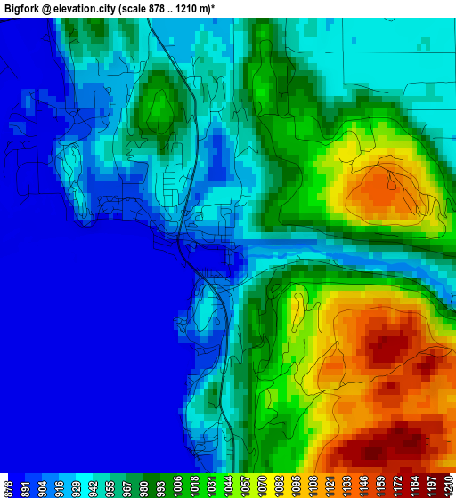
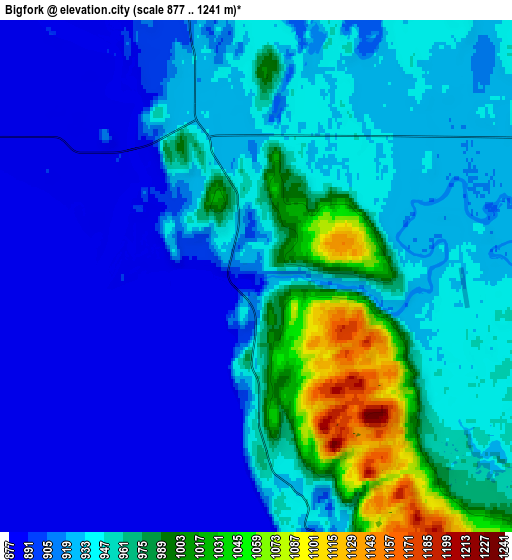
Below is the Elevation map of Bigfork, which displays elevation range with different colors. Scale of the first map is from 878 to 1210 m (2881 to 3970 ft) with average elevation of 964 meters (=3163 ft) [note 1]
These maps also provides idea of topography and contour of this city, they are displayed at different zoom levels. More info about maps, scale and edge coordinates you can find below images.

| \ | Map #1 | Map #2 | Topo.Map |
| Scale [m] | 878..1210 m | 877..1241 m | × |
| Scale [ft] | 2881..3970 ft | 2877..4072 ft | × |
| Average | 964 m = 3163 ft | 936.6 m = 3073 ft | × |
| Width | 6.53 km = 4.1 mi | 13.06 km = 8.1 mi | 209 km = 129.9 mi |
| Height | 6.53 km = 4.1 mi | 13.06 km = 8.1 mi | 209 km = 129.9 mi |
| ↑Max Latitude | 48.092651° | 48.121995° | 48.99453° |
| Latitude at center | 48.06329° | 48.06329° | 48.06329° |
| ↓Min Latitude | 48.033913° | 48.004518° | 47.11489° |
| ← Min Longitude | -114.116555° | -114.160501° | -115.47886° |
| Longitude center | -114.07261° | -114.07261° | -114.07261° |
| →Max Longitude | -114.028665° | -113.984719° | -112.66636° |
Nearby cities:
Cities around Bigfork sort by population:
• Kalispell elevation 904 m
23.1 km,  309°
309°
• Evergreen 891 m
23.6 km,  320°
320°
• Whitefish 928 m
43.4 km,  333°
333°
• Columbia Falls 938 m
35.3 km,  346°
346°
• Polson 892 m
41.7 km,  189°
189°
• Lakeside 888 m
12.3 km,  246°
246°
• Pablo 939 m
51.6 km,  183°
183°
• Ronan 931 m
59.5 km, 182°
• South Browning 1338 m
94.9 km,  55°
55°
• Somers 892 m
11.2 km,  279°
279°
• Plains 754 m
90.4 km,  222°
222°
• Browning 1331 m
95.6 km,  54°
54°
Multilingual:
 En español:
Bigfork elevación 908 m.
 En France:
Bigfork élévation 908 m.


Sources and notes:
- [note 1] Map square and city borders are not equal. Map elevation data is calculated only from area inside that square.
- [src 1] Elevation data from geonames database provided with same terms of usage.
- [src 2] The elevation map of Bigfork is generated using elevation data from NASA's 3 arcsec (90m) resolution SRTM data.
- [src 3] Base (background) map © OpenStreetMap contributors tiles are generated by Geofabrik and OpenTopoMap.
Copyright & License:
This Bigfork Elevation Map is licensed under CC BY-SA. You may reuse any part from this page, if you give a proper credit by linking to this URL:
 More info on terms of use page.