Monticello elevation
Monticello (Utah, San Juan County), United States elevation is 2159 meters and Monticello elevation in feet is 7083 ft above sea level [src 1]. Monticello is a seat of a second-order administrative division (feature code) with elevation that is 1880 meters (6168 ft) bigger than average city elevation in United States.
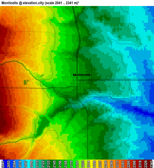
Below is the Elevation map of Monticello, which displays elevation range with different colors. Scale of the first map is from 2041 to 2341 m (6696 to 7680 ft) with average elevation of 2167.8 meters (=7112 ft) [note 1]
These maps also provides idea of topography and contour of this city, they are displayed at different zoom levels. More info about maps, scale and edge coordinates you can find below images.
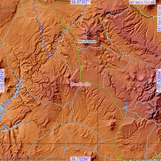
| \ | Map #1 | Topo.Map |
| Scale [m] | 2041..2341 m | × |
| Scale [ft] | 6696..7680 ft | × |
| Average | 2167.8 m = 7112 ft | × |
| Width | 7.71 km = 4.8 mi | 246.9 km = 153.4 mi |
| Height | 7.71 km = 4.8 mi | 246.8 km = 153.4 mi |
| ↑Max Latitude | 37.906062° | 38.97307° |
| Latitude at center | 37.87138° | 37.87138° |
| ↓Min Latitude | 37.836682° | 36.75296° |
| ← Min Longitude | -109.386835° | -110.74914° |
| Longitude center | -109.34289° | -109.34289° |
| →Max Longitude | -109.298945° | -107.93664° |
Nearby cities:
Cities around Monticello sort by population:
• Montrose elevation 1776 m
144.9 km,  62°
62°
• Durango 1998 m
145 km,  117°
117°
• Cortez 1895 m
88.4 km,  131°
131°
• Shiprock 1494 m
133.9 km,  154°
154°
• Moab 1233 m
80.1 km,  346°
346°
• Blanding 1868 m
30 km,  203°
203°
• Telluride 2683 m
134.5 km,  86°
86°
• Olathe 1636 m
144.1 km, 55°
• Mountain Village 2930 m
130.6 km, 87°
• Mancos 2144 m
109.7 km, 122°
• Towaoc 1803 m
91.8 km,  143°
143°
• Dove Creek 2093 m
40.1 km,  106°
106°
Multilingual:
 En español:
Monticello elevación 2159 m.
 En France:
Monticello élévation 2159 m.
 Auf Deutsch:
Monticello höhe über dem Meeresspiegel ist 2159 m.

Sources and notes:
- [note 1] Map square and city borders are not equal. Map elevation data is calculated only from area inside that square.
- [src 1] Elevation data from geonames database provided with same terms of usage.
- [src 2] The elevation map of Monticello is generated using elevation data from NASA's 3 arcsec (90m) resolution SRTM data.
- [src 3] Base (background) map © OpenStreetMap contributors tiles are generated by Geofabrik and OpenTopoMap.
Copyright & License:
This Monticello Elevation Map is licensed under CC BY-SA. You may reuse any part from this page, if you give a proper credit by linking to this URL:
 More info on terms of use page.