Olathe elevation
Olathe (Colorado, Montrose County), United States elevation is 1636 meters and Olathe elevation in feet is 5367 ft above sea level [src 1]. Olathe is a populated place (feature code) with elevation that is 1357 meters (4452 ft) bigger than average city elevation in United States.
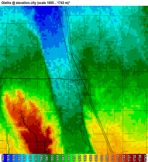
Below is the Elevation map of Olathe, which displays elevation range with different colors. Scale of the first map is from 1605 to 1743 m (5266 to 5719 ft) with average elevation of 1657.1 meters (=5437 ft) [note 1]
These maps also provides idea of topography and contour of this city, they are displayed at different zoom levels. More info about maps, scale and edge coordinates you can find below images.
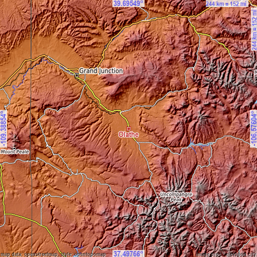
| \ | Map #1 | Topo.Map |
| Scale [m] | 1605..1743 m | × |
| Scale [ft] | 5266..5719 ft | × |
| Average | 1657.1 m = 5437 ft | × |
| Width | 7.64 km = 4.7 mi | 244.4 km = 151.9 mi |
| Height | 7.64 km = 4.7 mi | 244.4 km = 151.9 mi |
| ↑Max Latitude | 38.639324° | 39.69549° |
| Latitude at center | 38.60499° | 38.60499° |
| ↓Min Latitude | 38.57064° | 37.49766° |
| ← Min Longitude | -108.026235° | -109.38854° |
| Longitude center | -107.98229° | -107.98229° |
| →Max Longitude | -107.938345° | -106.57604° |
Nearby cities:
Cities around Olathe sort by population:
• Grand Junction elevation 1403 m
70.9 km,  316°
316°
• Clifton 1445 m
67.6 km, 323°
• Montrose 1776 m
16.8 km,  146°
146°
• Delta 1516 m
17 km,  333°
333°
• Fruitvale 1426 m
69.2 km, 319°
• Orchard Mesa 1421 m
69.4 km,  314°
314°
• Orchard City 1668 m
24.9 km,  2°
2°
• Palisade 1446 m
64.6 km, 330°
• Telluride 2683 m
75.7 km,  168°
168°
• Cedaredge 1905 m
33.3 km,  8°
8°
• Paonia 1739 m
44.8 km,  49°
49°
• Ouray 2380 m
70.2 km,  157°
157°
Multilingual:
 En español:
Olathe elevación 1636 m.
 En France:
Olathe élévation 1636 m.


Sources and notes:
- [note 1] Map square and city borders are not equal. Map elevation data is calculated only from area inside that square.
- [src 1] Elevation data from geonames database provided with same terms of usage.
- [src 2] The elevation map of Olathe is generated using elevation data from NASA's 3 arcsec (90m) resolution SRTM data.
- [src 3] Base (background) map © OpenStreetMap contributors tiles are generated by Geofabrik and OpenTopoMap.
Copyright & License:
This Olathe Elevation Map is licensed under CC BY-SA. You may reuse any part from this page, if you give a proper credit by linking to this URL:
 More info on terms of use page.