Montrose elevation
Montrose (Colorado, Montrose County), United States elevation is 1776 meters and Montrose elevation in feet is 5827 ft above sea level [src 1]. Montrose is a seat of a second-order administrative division (feature code) with elevation that is 1497 meters (4911 ft) bigger than average city elevation in United States.
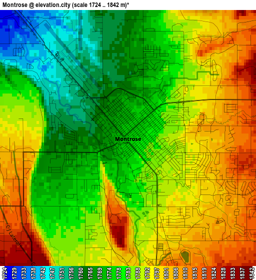
Below is the Elevation map of Montrose, which displays elevation range with different colors. Scale of the first map is from 1724 to 1842 m (5656 to 6043 ft) with average elevation of 1785.8 meters (=5859 ft) [note 1]
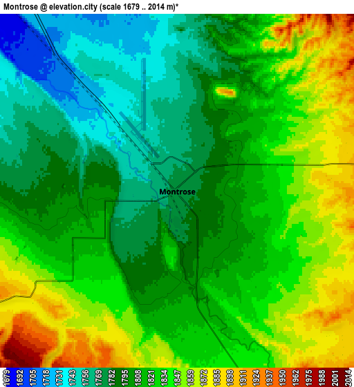
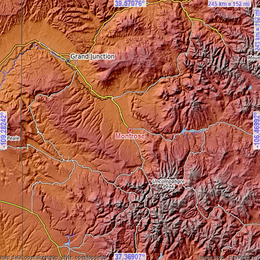
These maps also provides idea of topography and contour of this city, they are displayed at different zoom levels. More info about maps, scale and edge coordinates you can find below images.
| \ | Map #1 | Map #2 | Topo.Map |
| Scale [m] | 1724..1842 m | 1679..2014 m | × |
| Scale [ft] | 5656..6043 ft | 5509..6608 ft | × |
| Average | 1785.8 m = 5859 ft | 1815.3 m = 5956 ft | × |
| Width | 7.65 km = 4.8 mi | 15.3 km = 9.5 mi | 244.8 km = 152.1 mi |
| Height | 7.65 km = 4.8 mi | 15.3 km = 9.5 mi | 244.8 km = 152.1 mi |
| ↑Max Latitude | 38.512714° | 38.547092° | 39.57076° |
| Latitude at center | 38.47832° | 38.47832° | 38.47832° |
| ↓Min Latitude | 38.443909° | 38.409483° | 37.36907° |
| ← Min Longitude | -107.920115° | -107.964061° | -109.28242° |
| Longitude center | -107.87617° | -107.87617° | -107.87617° |
| →Max Longitude | -107.832225° | -107.788279° | -106.46992° |
Nearby cities:
Cities around Montrose sort by population:
• Delta elevation 1516 m
33.8 km,  330°
330°
• Gunnison 2353 m
83.1 km,  84°
84°
• Orchard City 1668 m
39.8 km,  348°
348°
• Palisade 1446 m
81.4 km, 329°
• Telluride 2683 m
60.4 km,  174°
174°
• Cedaredge 1905 m
47.3 km, 354°
• Olathe 1636 m
16.8 km, 326°
• Paonia 1739 m
49.9 km,  29°
29°
• Mountain Village 2930 m
60.8 km,  178°
178°
• Ouray 2380 m
53.7 km,  160°
160°
• Silverton 2840 m
76.4 km, 165°
• Lake City 2651 m
69.9 km,  135°
135°
Multilingual:
 En español:
Montrose elevación 1776 m.
 En France:
Montrose élévation 1776 m.
 Auf Deutsch:
Montrose höhe über dem Meeresspiegel ist 1776 m.

Sources and notes:
- [note 1] Map square and city borders are not equal. Map elevation data is calculated only from area inside that square.
- [src 1] Elevation data from geonames database provided with same terms of usage.
- [src 2] The elevation map of Montrose is generated using elevation data from NASA's 3 arcsec (90m) resolution SRTM data.
- [src 3] Base (background) map © OpenStreetMap contributors tiles are generated by Geofabrik and OpenTopoMap.
Copyright & License:
This Montrose Elevation Map is licensed under CC BY-SA. You may reuse any part from this page, if you give a proper credit by linking to this URL:
 More info on terms of use page.