Paonia elevation
Paonia (Colorado, Delta County), United States elevation is 1739 meters and Paonia elevation in feet is 5705 ft above sea level [src 1]. Paonia is a populated place (feature code) with elevation that is 1460 meters (4790 ft) bigger than average city elevation in United States.
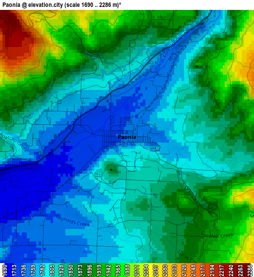
Below is the Elevation map of Paonia, which displays elevation range with different colors. Scale of the first map is from 1690 to 2286 m (5545 to 7500 ft) with average elevation of 1843.6 meters (=6049 ft) [note 1]
These maps also provides idea of topography and contour of this city, they are displayed at different zoom levels. More info about maps, scale and edge coordinates you can find below images.
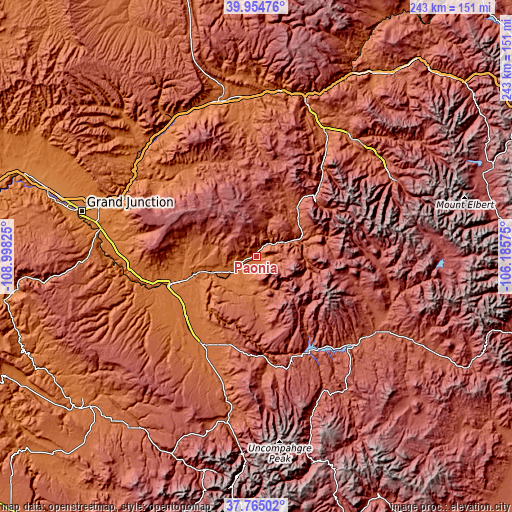
| \ | Map #1 | Topo.Map |
| Scale [m] | 1690..2286 m | × |
| Scale [ft] | 5545..7500 ft | × |
| Average | 1843.6 m = 6049 ft | × |
| Width | 7.61 km = 4.7 mi | 243.5 km = 151.3 mi |
| Height | 7.61 km = 4.7 mi | 243.5 km = 151.3 mi |
| ↑Max Latitude | 38.902527° | 39.95476° |
| Latitude at center | 38.86832° | 38.86832° |
| ↓Min Latitude | 38.834096° | 37.76502° |
| ← Min Longitude | -107.635945° | -108.99825° |
| Longitude center | -107.592° | -107.592° |
| →Max Longitude | -107.548055° | -106.18575° |
Nearby cities:
Cities around Paonia sort by population:
• Montrose elevation 1776 m
49.9 km,  209°
209°
• Delta 1516 m
43.6 km,  251°
251°
• Carbondale 1884 m
67.8 km,  28°
28°
• Gunnison 2353 m
68.1 km,  121°
121°
• Basalt 2023 m
73.7 km,  40°
40°
• El Jebel 1982 m
72.8 km, 36°
• Orchard City 1668 m
33.1 km,  262°
262°
• Snowmass Village 2503 m
68.3 km,  55°
55°
• Palisade 1446 m
70.9 km,  292°
292°
• Cedaredge 1905 m
29.2 km,  277°
277°
• Olathe 1636 m
44.8 km,  229°
229°
• Crested Butte 2720 m
52.3 km,  89°
89°
Multilingual:
 En español:
Paonia elevación 1739 m.
 En France:
Paonia élévation 1739 m.


Sources and notes:
- [note 1] Map square and city borders are not equal. Map elevation data is calculated only from area inside that square.
- [src 1] Elevation data from geonames database provided with same terms of usage.
- [src 2] The elevation map of Paonia is generated using elevation data from NASA's 3 arcsec (90m) resolution SRTM data.
- [src 3] Base (background) map © OpenStreetMap contributors tiles are generated by Geofabrik and OpenTopoMap.
Copyright & License:
This Paonia Elevation Map is licensed under CC BY-SA. You may reuse any part from this page, if you give a proper credit by linking to this URL:
 More info on terms of use page.