Cortez elevation
Cortez (Colorado, Montezuma County), United States elevation is 1895 meters and Cortez elevation in feet is 6217 ft above sea level [src 1]. Cortez is a seat of a second-order administrative division (feature code) with elevation that is 1616 meters (5302 ft) bigger than average city elevation in United States.
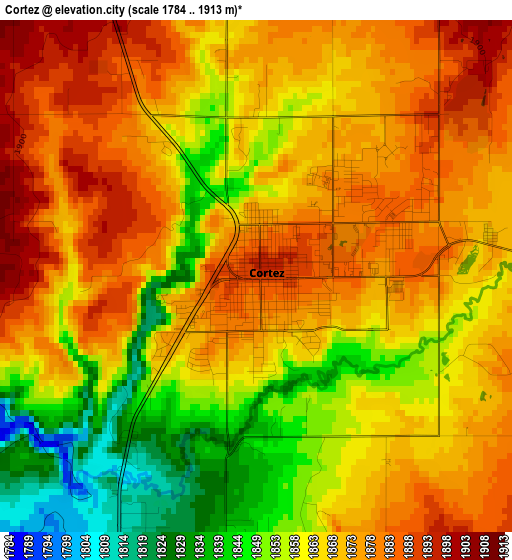
Below is the Elevation map of Cortez, which displays elevation range with different colors. Scale of the first map is from 1784 to 1913 m (5853 to 6276 ft) with average elevation of 1867.1 meters (=6126 ft) [note 1]
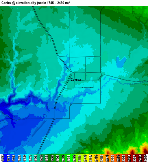
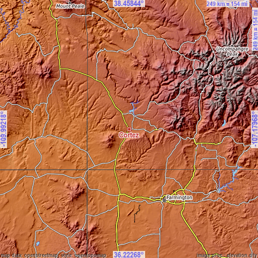
These maps also provides idea of topography and contour of this city, they are displayed at different zoom levels. More info about maps, scale and edge coordinates you can find below images.
| \ | Map #1 | Map #2 | Topo.Map |
| Scale [m] | 1784..1913 m | 1745..2430 m | × |
| Scale [ft] | 5853..6276 ft | 5725..7972 ft | × |
| Average | 1867.1 m = 6126 ft | 1896.5 m = 6222 ft | × |
| Width | 7.77 km = 4.8 mi | 15.54 km = 9.7 mi | 248.6 km = 154.5 mi |
| Height | 7.77 km = 4.8 mi | 15.54 km = 9.7 mi | 248.6 km = 154.5 mi |
| ↑Max Latitude | 37.383806° | 37.418717° | 38.45844° |
| Latitude at center | 37.34888° | 37.34888° | 37.34888° |
| ↓Min Latitude | 37.313937° | 37.278978° | 36.22268° |
| ← Min Longitude | -108.629875° | -108.673821° | -109.99218° |
| Longitude center | -108.58593° | -108.58593° | -108.58593° |
| →Max Longitude | -108.541985° | -108.498039° | -107.17968° |
Nearby cities:
Cities around Cortez sort by population:
• Farmington elevation 1614 m
76.3 km,  154°
154°
• Durango 1998 m
63 km,  97°
97°
• Shiprock 1494 m
63.3 km,  188°
188°
• Kirtland 1582 m
71.2 km,  163°
163°
• Aztec 1727 m
78.7 km,  138°
138°
• Flora Vista 1680 m
76.2 km, 143°
• Waterflow 1547 m
66.2 km,  171°
171°
• Upper Fruitland 1593 m
74.4 km, 161°
• Mancos 2144 m
26.2 km,  90°
90°
• Spencerville 1733 m
75.2 km, 141°
• Towaoc 1803 m
20.5 km,  218°
218°
• Dove Creek 2093 m
54.3 km,  328°
328°
Multilingual:
 En español:
Cortez elevación 1895 m.
 En France:
Cortez élévation 1895 m.


Sources and notes:
- [note 1] Map square and city borders are not equal. Map elevation data is calculated only from area inside that square.
- [src 1] Elevation data from geonames database provided with same terms of usage.
- [src 2] The elevation map of Cortez is generated using elevation data from NASA's 3 arcsec (90m) resolution SRTM data.
- [src 3] Base (background) map © OpenStreetMap contributors tiles are generated by Geofabrik and OpenTopoMap.
Copyright & License:
This Cortez Elevation Map is licensed under CC BY-SA. You may reuse any part from this page, if you give a proper credit by linking to this URL:
 More info on terms of use page.