Blanding elevation
Blanding (Utah, San Juan County), United States elevation is 1868 meters and Blanding elevation in feet is 6129 ft above sea level [src 1]. Blanding is a populated place (feature code) with elevation that is 1589 meters (5213 ft) bigger than average city elevation in United States.
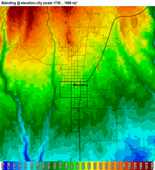
Below is the Elevation map of Blanding, which displays elevation range with different colors. Scale of the first map is from 1738 to 1988 m (5702 to 6522 ft) with average elevation of 1851 meters (=6073 ft) [note 1]
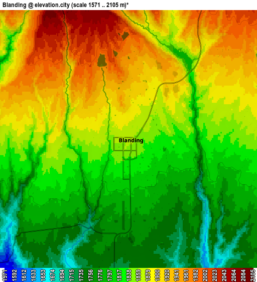
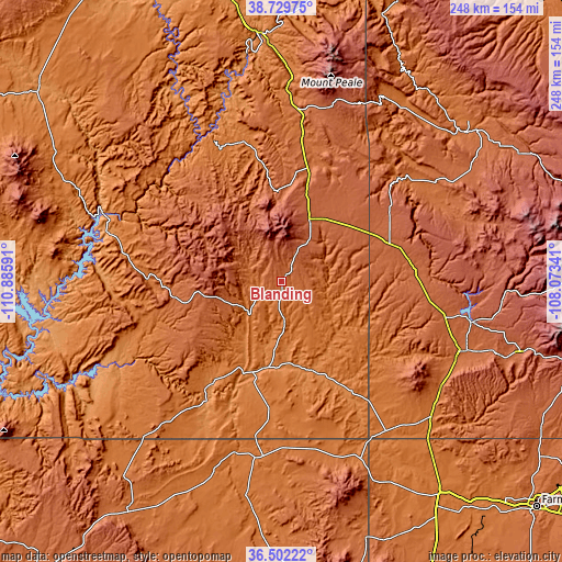
These maps also provides idea of topography and contour of this city, they are displayed at different zoom levels. More info about maps, scale and edge coordinates you can find below images.
| \ | Map #1 | Map #2 | Topo.Map |
| Scale [m] | 1738..1988 m | 1571..2105 m | × |
| Scale [ft] | 5702..6522 ft | 5154..6906 ft | × |
| Average | 1851 m = 6073 ft | 1849.6 m = 6068 ft | × |
| Width | 7.74 km = 4.8 mi | 15.48 km = 9.6 mi | 247.7 km = 153.9 mi |
| Height | 7.74 km = 4.8 mi | 15.48 km = 9.6 mi | 247.7 km = 153.9 mi |
| ↑Max Latitude | 37.659128° | 37.693909° | 38.72975° |
| Latitude at center | 37.62433° | 37.62433° | 37.62433° |
| ↓Min Latitude | 37.589516° | 37.554685° | 36.50222° |
| ← Min Longitude | -109.523605° | -109.567551° | -110.88591° |
| Longitude center | -109.47966° | -109.47966° | -109.47966° |
| →Max Longitude | -109.435715° | -109.391769° | -108.07341° |
Nearby cities:
Cities around Blanding sort by population:
• Cortez elevation 1895 m
84.6 km,  111°
111°
• Shiprock 1494 m
116.7 km,  143°
143°
• Kirtland 1582 m
140.1 km,  134°
134°
• Moab 1233 m
105.7 km,  356°
356°
• Kayenta 1721 m
121 km,  214°
214°
• Monticello 2159 m
30 km,  23°
23°
• Lukachukai 1999 m
136.1 km,  170°
170°
• Waterflow 1547 m
130.6 km, 137°
• Mancos 2144 m
109.5 km, 106°
• Many Farms 1619 m
141.9 km,  184°
184°
• Towaoc 1803 m
81 km, 125°
• Dove Creek 2093 m
52.9 km,  72°
72°
Multilingual:
 En español:
Blanding elevación 1868 m.
 En France:
Blanding élévation 1868 m.
 Auf Deutsch:
Blanding höhe über dem Meeresspiegel ist 1868 m.

Sources and notes:
- [note 1] Map square and city borders are not equal. Map elevation data is calculated only from area inside that square.
- [src 1] Elevation data from geonames database provided with same terms of usage.
- [src 2] The elevation map of Blanding is generated using elevation data from NASA's 3 arcsec (90m) resolution SRTM data.
- [src 3] Base (background) map © OpenStreetMap contributors tiles are generated by Geofabrik and OpenTopoMap.
Copyright & License:
This Blanding Elevation Map is licensed under CC BY-SA. You may reuse any part from this page, if you give a proper credit by linking to this URL:
 More info on terms of use page.