Kayenta elevation
Kayenta (Arizona, Navajo County), United States elevation is 1721 meters and Kayenta elevation in feet is 5646 ft above sea level [src 1]. Kayenta is a populated place (feature code) with elevation that is 1442 meters (4731 ft) bigger than average city elevation in United States.
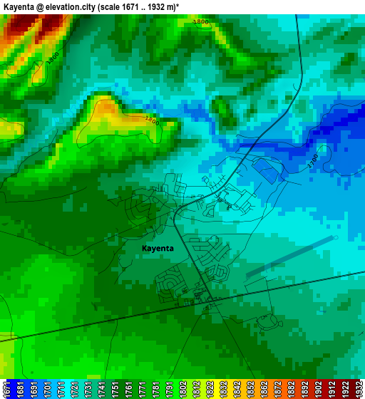
Below is the Elevation map of Kayenta, which displays elevation range with different colors. Scale of the first map is from 1671 to 1932 m (5482 to 6339 ft) with average elevation of 1748.9 meters (=5738 ft) [note 1]
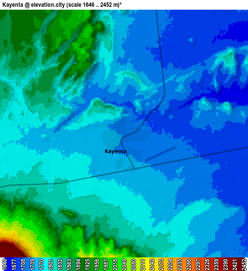
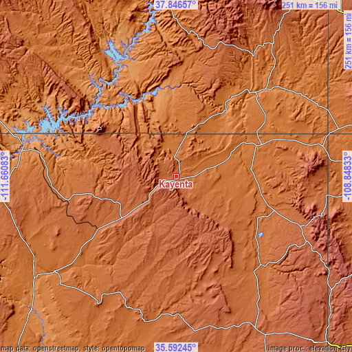
These maps also provides idea of topography and contour of this city, they are displayed at different zoom levels. More info about maps, scale and edge coordinates you can find below images.
| \ | Map #1 | Map #2 | Topo.Map |
| Scale [m] | 1671..1932 m | 1646..2452 m | × |
| Scale [ft] | 5482..6339 ft | 5400..8045 ft | × |
| Average | 1748.9 m = 5738 ft | 1788.7 m = 5868 ft | × |
| Width | 7.83 km = 4.9 mi | 15.67 km = 9.7 mi | 250.6 km = 155.7 mi |
| Height | 7.83 km = 4.9 mi | 15.67 km = 9.7 mi | 250.6 km = 155.7 mi |
| ↑Max Latitude | 36.762993° | 36.798191° | 37.84657° |
| Latitude at center | 36.72778° | 36.72778° | 36.72778° |
| ↓Min Latitude | 36.69255° | 36.657305° | 35.59245° |
| ← Min Longitude | -110.298525° | -110.342471° | -111.66083° |
| Longitude center | -110.25458° | -110.25458° | -110.25458° |
| →Max Longitude | -110.210635° | -110.166689° | -108.84833° |
Nearby cities:
Cities around Kayenta sort by population:
• Tuba City elevation 1517 m
110.1 km,  233°
233°
• Shiprock 1494 m
139.8 km,  87°
87°
• Page 1327 m
108.9 km,  281°
281°
• Chinle 1682 m
89.5 km,  135°
135°
• Blanding 1868 m
121 km,  34°
34°
• Lukachukai 1999 m
97.9 km,  110°
110°
• First Mesa 1766 m
99.7 km,  186°
186°
• Kaibito 1769 m
74.5 km,  258°
258°
• LeChee 1381 m
106.7 km, 278°
• Many Farms 1619 m
70.5 km,  126°
126°
• Ganado 1949 m
129.8 km,  150°
150°
• Tsaile 2147 m
104.1 km,  116°
116°
Multilingual:
 En español:
Kayenta elevación 1721 m.
 En France:
Kayenta élévation 1721 m.
 Auf Deutsch:
Kayenta höhe über dem Meeresspiegel ist 1721 m.

Sources and notes:
- [note 1] Map square and city borders are not equal. Map elevation data is calculated only from area inside that square.
- [src 1] Elevation data from geonames database provided with same terms of usage.
- [src 2] The elevation map of Kayenta is generated using elevation data from NASA's 3 arcsec (90m) resolution SRTM data.
- [src 3] Base (background) map © OpenStreetMap contributors tiles are generated by Geofabrik and OpenTopoMap.
Copyright & License:
This Kayenta Elevation Map is licensed under CC BY-SA. You may reuse any part from this page, if you give a proper credit by linking to this URL:
 More info on terms of use page.