LeChee elevation
LeChee (Arizona, Coconino County), United States elevation is 1381 meters and LeChee elevation in feet is 4531 ft above sea level [src 1]. LeChee is a populated place (feature code) with elevation that is 1102 meters (3615 ft) bigger than average city elevation in United States.
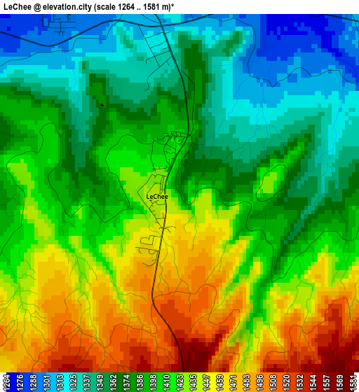
Below is the Elevation map of LeChee, which displays elevation range with different colors. Scale of the first map is from 1264 to 1581 m (4147 to 5187 ft) with average elevation of 1402.4 meters (=4601 ft) [note 1]
These maps also provides idea of topography and contour of this city, they are displayed at different zoom levels. More info about maps, scale and edge coordinates you can find below images.
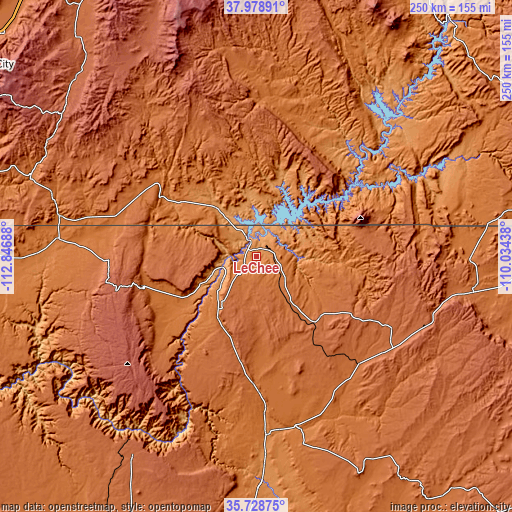
| \ | Map #1 | Topo.Map |
| Scale [m] | 1264..1581 m | × |
| Scale [ft] | 4147..5187 ft | × |
| Average | 1402.4 m = 4601 ft | × |
| Width | 7.82 km = 4.9 mi | 250.2 km = 155.5 mi |
| Height | 7.82 km = 4.9 mi | 250.2 km = 155.5 mi |
| ↑Max Latitude | 36.897262° | 37.97891° |
| Latitude at center | 36.86211° | 36.86211° |
| ↓Min Latitude | 36.826942° | 35.72875° |
| ← Min Longitude | -111.484575° | -112.84688° |
| Longitude center | -111.44063° | -111.44063° |
| →Max Longitude | -111.396685° | -110.03438° |
Nearby cities:
Cities around LeChee sort by population:
• Tuba City elevation 1517 m
82.8 km,  167°
167°
• Page 1327 m
6 km,  346°
346°
• Kayenta 1721 m
106.7 km,  98°
98°
• Colorado City 1520 m
137.2 km,  275°
275°
• Kanab 1518 m
98.6 km, 282°
• Hildale 1536 m
136.6 km, 276°
• Grand Canyon Village 2056 m
110.9 km,  215°
215°
• Kaibito 1769 m
44 km,  132°
132°
• Panguitch 2021 m
138.4 km,  320°
320°
• Grand Canyon 2105 m
109.4 km,  214°
214°
• Fredonia 1426 m
97 km, 275°
• Centennial Park 1495 m
137.4 km,  274°
274°
Multilingual:
 En español:
LeChee elevación 1381 m.
 En France:
LeChee élévation 1381 m.


Sources and notes:
- [note 1] Map square and city borders are not equal. Map elevation data is calculated only from area inside that square.
- [src 1] Elevation data from geonames database provided with same terms of usage.
- [src 2] The elevation map of LeChee is generated using elevation data from NASA's 3 arcsec (90m) resolution SRTM data.
- [src 3] Base (background) map © OpenStreetMap contributors tiles are generated by Geofabrik and OpenTopoMap.
Copyright & License:
This LeChee Elevation Map is licensed under CC BY-SA. You may reuse any part from this page, if you give a proper credit by linking to this URL:
 More info on terms of use page.