Panguitch elevation
Panguitch (Utah, Garfield County), United States elevation is 2021 meters and Panguitch elevation in feet is 6631 ft above sea level [src 1]. Panguitch is a seat of a second-order administrative division (feature code) with elevation that is 1742 meters (5715 ft) bigger than average city elevation in United States.
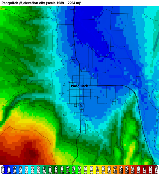
Below is the Elevation map of Panguitch, which displays elevation range with different colors. Scale of the first map is from 1989 to 2294 m (6526 to 7526 ft) with average elevation of 2071.6 meters (=6797 ft) [note 1]
These maps also provides idea of topography and contour of this city, they are displayed at different zoom levels. More info about maps, scale and edge coordinates you can find below images.
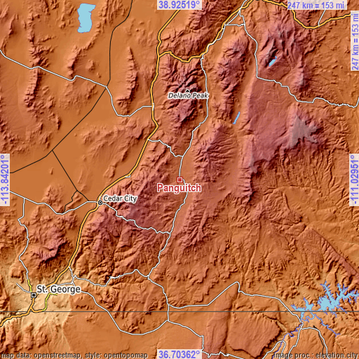
| \ | Map #1 | Topo.Map |
| Scale [m] | 1989..2294 m | × |
| Scale [ft] | 6526..7526 ft | × |
| Average | 2071.6 m = 6797 ft | × |
| Width | 7.72 km = 4.8 mi | 247 km = 153.5 mi |
| Height | 7.72 km = 4.8 mi | 247 km = 153.5 mi |
| ↑Max Latitude | 37.857465° | 38.92519° |
| Latitude at center | 37.82276° | 37.82276° |
| ↓Min Latitude | 37.788039° | 36.70362° |
| ← Min Longitude | -112.479705° | -113.84201° |
| Longitude center | -112.43576° | -112.43576° |
| →Max Longitude | -112.391815° | -111.02951° |
Nearby cities:
Cities around Panguitch sort by population:
• Cedar City elevation 1784 m
57.4 km,  253°
253°
• Enoch 1694 m
52 km,  263°
263°
• Kanab 1518 m
86.6 km,  185°
185°
• LaVerkin 978 m
100.9 km,  226°
226°
• Beaver 1803 m
53.6 km,  340°
340°
• Parowan 1835 m
34.5 km,  273°
273°
• Monroe 1647 m
93.9 km,  17°
17°
• Toquerville 1033 m
98 km, 229°
• Milford 1517 m
81.3 km,  321°
321°
• Fredonia 1426 m
97.9 km,  184°
184°
• Loa 2158 m
94.7 km,  47°
47°
• Junction 1834 m
49.8 km, 22°
Multilingual:
 En español:
Panguitch elevación 2021 m.
 En France:
Panguitch élévation 2021 m.
 Auf Deutsch:
Panguitch höhe über dem Meeresspiegel ist 2021 m.

Sources and notes:
- [note 1] Map square and city borders are not equal. Map elevation data is calculated only from area inside that square.
- [src 1] Elevation data from geonames database provided with same terms of usage.
- [src 2] The elevation map of Panguitch is generated using elevation data from NASA's 3 arcsec (90m) resolution SRTM data.
- [src 3] Base (background) map © OpenStreetMap contributors tiles are generated by Geofabrik and OpenTopoMap.
Copyright & License:
This Panguitch Elevation Map is licensed under CC BY-SA. You may reuse any part from this page, if you give a proper credit by linking to this URL:
 More info on terms of use page.