LaVerkin elevation
LaVerkin (Utah, Washington County), United States elevation is 978 meters and LaVerkin elevation in feet is 3209 ft above sea level [src 1]. LaVerkin is a populated place (feature code) with elevation that is 699 meters (2293 ft) bigger than average city elevation in United States.
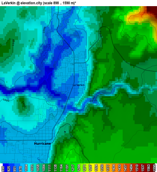
Below is the Elevation map of LaVerkin, which displays elevation range with different colors. Scale of the first map is from 898 to 1590 m (2946 to 5217 ft) with average elevation of 1074.6 meters (=3526 ft) [note 1]
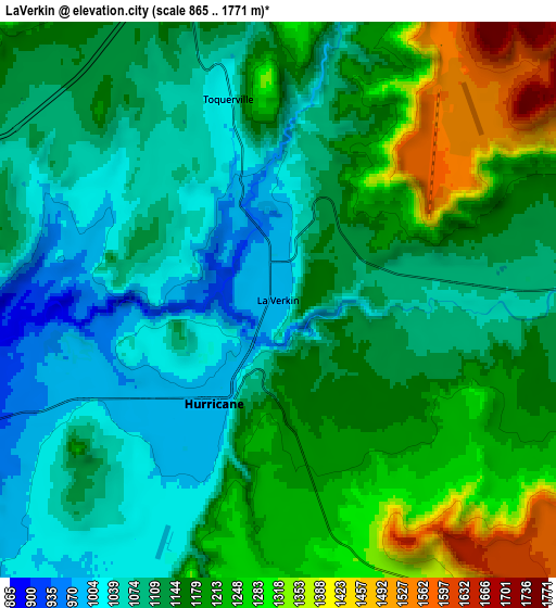
These maps also provides idea of topography and contour of this city, they are displayed at different zoom levels. More info about maps, scale and edge coordinates you can find below images.
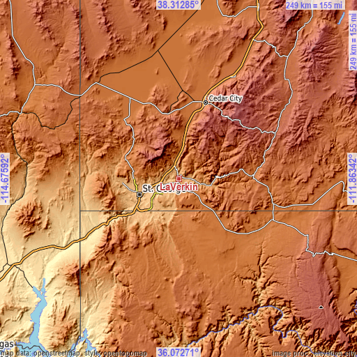
| \ | Map #1 | Map #2 | Topo.Map |
| Scale [m] | 898..1590 m | 865..1771 m | × |
| Scale [ft] | 2946..5217 ft | 2838..5810 ft | × |
| Average | 1074.6 m = 3526 ft | 1151.8 m = 3779 ft | × |
| Width | 7.78 km = 4.8 mi | 15.57 km = 9.7 mi | 249.1 km = 154.8 mi |
| Height | 7.78 km = 4.8 mi | 15.57 km = 9.7 mi | 249.1 km = 154.8 mi |
| ↑Max Latitude | 37.236085° | 37.271064° | 38.31285° |
| Latitude at center | 37.20109° | 37.20109° | 37.20109° |
| ↓Min Latitude | 37.166079° | 37.131051° | 36.07271° |
| ← Min Longitude | -113.313615° | -113.357561° | -114.67592° |
| Longitude center | -113.26967° | -113.26967° | -113.26967° |
| →Max Longitude | -113.225725° | -113.181779° | -111.86342° |
Nearby cities:
Cities around LaVerkin sort by population:
• Saint George elevation 825 m
29.9 km,  248°
248°
• Cedar City 1784 m
56.1 km,  19°
19°
• Washington 857 m
22.6 km, 249°
• Hurricane 991 m
3.4 km,  212°
212°
• Ivins 941 m
36.5 km,  264°
264°
• Santa Clara 848 m
34.9 km, 257°
• Enoch 1694 m
67.2 km, 18°
• Colorado City 1520 m
35.1 km,  131°
131°
• Hildale 1536 m
34.7 km, 129°
• Enterprise 1625 m
57.4 km,  316°
316°
• Toquerville 1033 m
6 km,  347°
347°
• Centennial Park 1495 m
37.6 km,  137°
137°
Multilingual:
 En español:
LaVerkin elevación 978 m.
 En France:
LaVerkin élévation 978 m.
 Auf Deutsch:
LaVerkin höhe über dem Meeresspiegel ist 978 m.

Sources and notes:
- [note 1] Map square and city borders are not equal. Map elevation data is calculated only from area inside that square.
- [src 1] Elevation data from geonames database provided with same terms of usage.
- [src 2] The elevation map of LaVerkin is generated using elevation data from NASA's 3 arcsec (90m) resolution SRTM data.
- [src 3] Base (background) map © OpenStreetMap contributors tiles are generated by Geofabrik and OpenTopoMap.
Copyright & License:
This LaVerkin Elevation Map is licensed under CC BY-SA. You may reuse any part from this page, if you give a proper credit by linking to this URL:
 More info on terms of use page.