Kaibito elevation
Kaibito (Arizona, Coconino County), United States elevation is 1769 meters and Kaibito elevation in feet is 5804 ft above sea level [src 1]. Kaibito is a populated place (feature code) with elevation that is 1490 meters (4888 ft) bigger than average city elevation in United States.
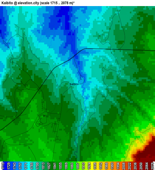
Below is the Elevation map of Kaibito, which displays elevation range with different colors. Scale of the first map is from 1715 to 2078 m (5627 to 6818 ft) with average elevation of 1820.1 meters (=5971 ft) [note 1]
These maps also provides idea of topography and contour of this city, they are displayed at different zoom levels. More info about maps, scale and edge coordinates you can find below images.
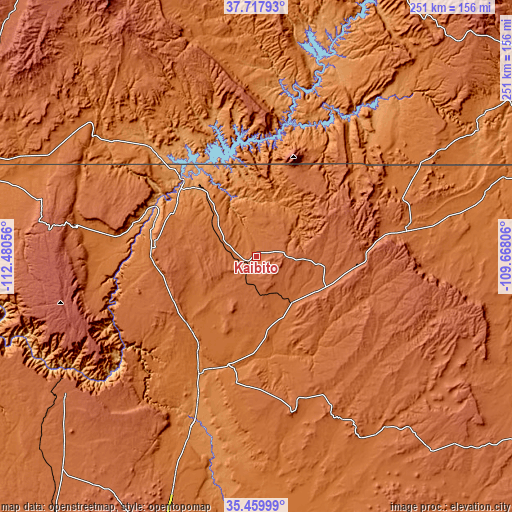
| \ | Map #1 | Topo.Map |
| Scale [m] | 1715..2078 m | × |
| Scale [ft] | 5627..6818 ft | × |
| Average | 1820.1 m = 5971 ft | × |
| Width | 7.85 km = 4.9 mi | 251.1 km = 156 mi |
| Height | 7.85 km = 4.9 mi | 251.1 km = 156 mi |
| ↑Max Latitude | 36.632493° | 37.71793° |
| Latitude at center | 36.59722° | 36.59722° |
| ↓Min Latitude | 36.561931° | 35.45999° |
| ← Min Longitude | -111.118255° | -112.48056° |
| Longitude center | -111.07431° | -111.07431° |
| →Max Longitude | -111.030365° | -109.66806° |
Nearby cities:
Cities around Kaibito sort by population:
• Tuba City elevation 1517 m
53.5 km,  196°
196°
• Page 1327 m
49 km,  316°
316°
• Kayenta 1721 m
74.5 km,  78°
78°
• Chinle 1682 m
144.8 km,  109°
109°
• Kanab 1518 m
138.6 km,  291°
291°
• First Mesa 1766 m
104.9 km,  143°
143°
• Grand Canyon Village 2056 m
114.5 km,  237°
237°
• Grand Canyon 2105 m
112.9 km, 237°
• LeChee 1381 m
44 km,  312°
312°
• Many Farms 1619 m
133 km,  101°
101°
• Fredonia 1426 m
135 km, 286°
• Dilkon 1798 m
150.8 km,  153°
153°
Multilingual:
 En español:
Kaibito elevación 1769 m.
 En France:
Kaibito élévation 1769 m.
 Auf Deutsch:
Kaibito höhe über dem Meeresspiegel ist 1769 m.

Sources and notes:
- [note 1] Map square and city borders are not equal. Map elevation data is calculated only from area inside that square.
- [src 1] Elevation data from geonames database provided with same terms of usage.
- [src 2] The elevation map of Kaibito is generated using elevation data from NASA's 3 arcsec (90m) resolution SRTM data.
- [src 3] Base (background) map © OpenStreetMap contributors tiles are generated by Geofabrik and OpenTopoMap.
Copyright & License:
This Kaibito Elevation Map is licensed under CC BY-SA. You may reuse any part from this page, if you give a proper credit by linking to this URL:
 More info on terms of use page.