Sanderson elevation
Sanderson (Texas, Terrell County), United States elevation is 849 meters and Sanderson elevation in feet is 2785 ft above sea level [src 1]. Sanderson is a seat of a second-order administrative division (feature code) with elevation that is 570 meters (1870 ft) bigger than average city elevation in United States.
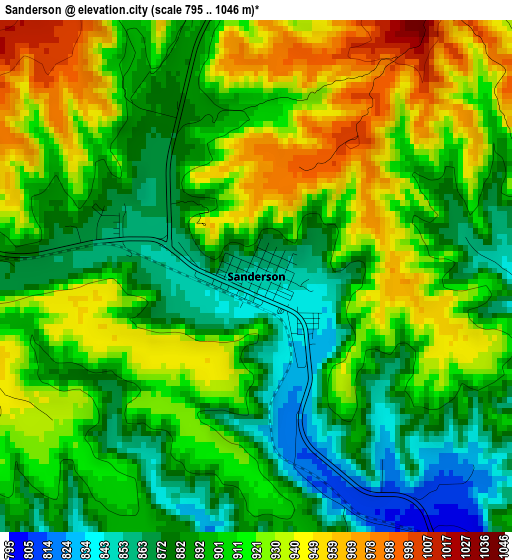
Below is the Elevation map of Sanderson, which displays elevation range with different colors. Scale of the first map is from 795 to 1046 m (2608 to 3432 ft) with average elevation of 905.4 meters (=2970 ft) [note 1]
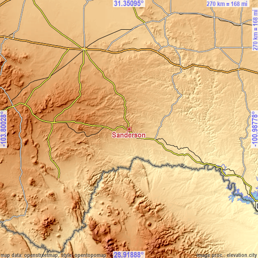
These maps also provides idea of topography and contour of this city, they are displayed at different zoom levels. More info about maps, scale and edge coordinates you can find below images.
| \ | Map #1 | Topo.Map |
| Scale [m] | 795..1046 m | × |
| Scale [ft] | 2608..3432 ft | × |
| Average | 905.4 m = 2970 ft | × |
| Width | 8.45 km = 5.3 mi | 270.4 km = 168 mi |
| Height | 8.45 km = 5.3 mi | 270.4 km = 168 mi |
| ↑Max Latitude | 30.180406° | 31.35095° |
| Latitude at center | 30.14241° | 30.14241° |
| ↓Min Latitude | 30.1044° | 28.91888° |
| ← Min Longitude | -102.437975° | -103.80028° |
| Longitude center | -102.39403° | -102.39403° |
| →Max Longitude | -102.350085° | -100.98778° |
Nearby cities:
Cities around Sanderson sort by population:
• Fort Stockton elevation 904 m
95.6 km,  330°
330°
• Monahans 800 m
168.3 km,  343°
343°
• Alpine 1367 m
124.1 km,  281°
281°
• Crane 784 m
139.6 km,  1°
1°
• Cienegas Terrace 292 m
164.4 km,  121°
121°
• Big Lake 821 m
146.9 km,  37°
37°
• Ozona 719 m
130.7 km,  61°
61°
• McCamey 750 m
111.7 km,  8°
8°
• Marfa 1430 m
157.4 km, 276°
• Iraan 678 m
98.1 km,  28°
28°
• Fort Davis 1494 m
152.3 km,  288°
288°
• Rankin 764 m
127.8 km,  19°
19°
Multilingual:
 En español:
Sanderson elevación 849 m.
 En France:
Sanderson élévation 849 m.
 Auf Deutsch:
Sanderson höhe über dem Meeresspiegel ist 849 m.

Sources and notes:
- [note 1] Map square and city borders are not equal. Map elevation data is calculated only from area inside that square.
- [src 1] Elevation data from geonames database provided with same terms of usage.
- [src 2] The elevation map of Sanderson is generated using elevation data from NASA's 3 arcsec (90m) resolution SRTM data.
- [src 3] Base (background) map © OpenStreetMap contributors tiles are generated by Geofabrik and OpenTopoMap.
Copyright & License:
This Sanderson Elevation Map is licensed under CC BY-SA. You may reuse any part from this page, if you give a proper credit by linking to this URL:
 More info on terms of use page.