Rankin elevation
Rankin (Texas, Upton County), United States elevation is 764 meters and Rankin elevation in feet is 2507 ft above sea level [src 1]. Rankin is a seat of a second-order administrative division (feature code) with elevation that is 485 meters (1591 ft) bigger than average city elevation in United States.
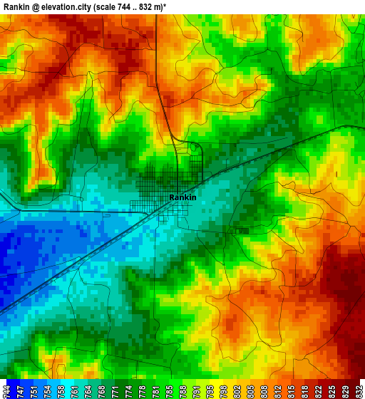
Below is the Elevation map of Rankin, which displays elevation range with different colors. Scale of the first map is from 744 to 832 m (2441 to 2730 ft) with average elevation of 787.9 meters (=2585 ft) [note 1]
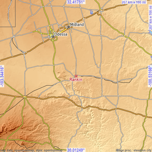
These maps also provides idea of topography and contour of this city, they are displayed at different zoom levels. More info about maps, scale and edge coordinates you can find below images.
| \ | Map #1 | Topo.Map |
| Scale [m] | 744..832 m | × |
| Scale [ft] | 2441..2730 ft | × |
| Average | 787.9 m = 2585 ft | × |
| Width | 8.36 km = 5.2 mi | 267.4 km = 166.2 mi |
| Height | 8.36 km = 5.2 mi | 267.4 km = 166.2 mi |
| ↑Max Latitude | 31.260223° | 32.41751° |
| Latitude at center | 31.22265° | 31.22265° |
| ↓Min Latitude | 31.185062° | 30.01249° |
| ← Min Longitude | -101.981855° | -103.34416° |
| Longitude center | -101.93791° | -101.93791° |
| →Max Longitude | -101.893965° | -100.53166° |
Nearby cities:
Cities around Rankin sort by population:
• Midland elevation 862 m
87.2 km,  351°
351°
• Odessa 885 m
80.4 km,  329°
329°
• West Odessa 902 m
87 km,  322°
322°
• Fort Stockton 904 m
96.8 km,  247°
247°
• Monahans 800 m
99.6 km,  294°
294°
• Crane 784 m
43.7 km,  296°
296°
• Big Lake 821 m
45.5 km,  94°
94°
• Ozona 719 m
90.5 km,  129°
129°
• McCamey 750 m
28.9 km, 250°
• Gardendale 905 m
98.1 km, 334°
• Iraan 678 m
34.5 km,  173°
173°
• Garden City 805 m
83.4 km,  31°
31°
Multilingual:
 En español:
Rankin elevación 764 m.
 En France:
Rankin élévation 764 m.


Sources and notes:
- [note 1] Map square and city borders are not equal. Map elevation data is calculated only from area inside that square.
- [src 1] Elevation data from geonames database provided with same terms of usage.
- [src 2] The elevation map of Rankin is generated using elevation data from NASA's 3 arcsec (90m) resolution SRTM data.
- [src 3] Base (background) map © OpenStreetMap contributors tiles are generated by Geofabrik and OpenTopoMap.
Copyright & License:
This Rankin Elevation Map is licensed under CC BY-SA. You may reuse any part from this page, if you give a proper credit by linking to this URL:
 More info on terms of use page.