Ozona elevation
Ozona (Texas, Crockett County), United States elevation is 719 meters and Ozona elevation in feet is 2359 ft above sea level [src 1]. Ozona is a seat of a second-order administrative division (feature code) with elevation that is 440 meters (1444 ft) bigger than average city elevation in United States.
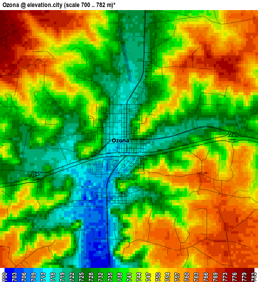
Below is the Elevation map of Ozona, which displays elevation range with different colors. Scale of the first map is from 700 to 782 m (2297 to 2566 ft) with average elevation of 741.4 meters (=2432 ft) [note 1]
These maps also provides idea of topography and contour of this city, they are displayed at different zoom levels. More info about maps, scale and edge coordinates you can find below images.
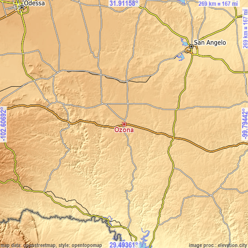
| \ | Map #1 | Topo.Map |
| Scale [m] | 700..782 m | × |
| Scale [ft] | 2297..2566 ft | × |
| Average | 741.4 m = 2432 ft | × |
| Width | 8.4 km = 5.2 mi | 268.9 km = 167.1 mi |
| Height | 8.4 km = 5.2 mi | 268.9 km = 167.1 mi |
| ↑Max Latitude | 30.747945° | 31.91158° |
| Latitude at center | 30.71017° | 30.71017° |
| ↓Min Latitude | 30.67238° | 29.49361° |
| ← Min Longitude | -101.244615° | -102.60692° |
| Longitude center | -101.20067° | -101.20067° |
| →Max Longitude | -101.156725° | -99.79442° |
Nearby cities:
Cities around Ozona sort by population:
• San Angelo elevation 564 m
110.9 km,  40°
40°
• Big Lake 821 m
59 km,  335°
335°
• Grape Creek 607 m
114.9 km,  32°
32°
• Sonora 650 m
55.6 km,  106°
106°
• McCamey 750 m
108.5 km,  295°
295°
• Eldorado 746 m
59.7 km,  73°
73°
• Iraan 678 m
70.3 km,  288°
288°
• Rocksprings 735 m
122.8 km,  128°
128°
• Sterling City 696 m
126.9 km,  9°
9°
• Rankin 764 m
90.5 km,  309°
309°
• Sanderson 849 m
130.7 km,  241°
241°
• Mertzon 671 m
71.4 km, 30°
Multilingual:
 En español:
Ozona elevación 719 m.
 En France:
Ozona élévation 719 m.


Sources and notes:
- [note 1] Map square and city borders are not equal. Map elevation data is calculated only from area inside that square.
- [src 1] Elevation data from geonames database provided with same terms of usage.
- [src 2] The elevation map of Ozona is generated using elevation data from NASA's 3 arcsec (90m) resolution SRTM data.
- [src 3] Base (background) map © OpenStreetMap contributors tiles are generated by Geofabrik and OpenTopoMap.
Copyright & License:
This Ozona Elevation Map is licensed under CC BY-SA. You may reuse any part from this page, if you give a proper credit by linking to this URL:
 More info on terms of use page.