Garden City elevation
Garden City (Texas, Glasscock County), United States elevation is 805 meters and Garden City elevation in feet is 2641 ft above sea level [src 1]. Garden City is a seat of a second-order administrative division (feature code) with elevation that is 526 meters (1726 ft) bigger than average city elevation in United States.
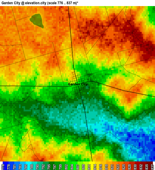
Below is the Elevation map of Garden City, which displays elevation range with different colors. Scale of the first map is from 776 to 837 m (2546 to 2746 ft) with average elevation of 809.3 meters (=2655 ft) [note 1]
These maps also provides idea of topography and contour of this city, they are displayed at different zoom levels. More info about maps, scale and edge coordinates you can find below images.
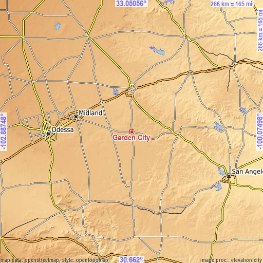
| \ | Map #1 | Topo.Map |
| Scale [m] | 776..837 m | × |
| Scale [ft] | 2546..2746 ft | × |
| Average | 809.3 m = 2655 ft | × |
| Width | 8.3 km = 5.2 mi | 265.6 km = 165 mi |
| Height | 8.3 km = 5.2 mi | 265.6 km = 165 mi |
| ↑Max Latitude | 31.901335° | 33.05056° |
| Latitude at center | 31.86402° | 31.86402° |
| ↓Min Latitude | 31.82669° | 30.662° |
| ← Min Longitude | -101.525175° | -102.88748° |
| Longitude center | -101.48123° | -101.48123° |
| →Max Longitude | -101.437285° | -100.07498° |
Nearby cities:
Cities around Garden City sort by population:
• Midland elevation 862 m
58.2 km,  284°
284°
• Odessa 885 m
83.7 km,  268°
268°
• Big Spring 747 m
43 km,  0°
0°
• Colorado City 629 m
82.3 km,  44°
44°
• Big Lake 821 m
74.8 km,  178°
178°
• Grape Creek 607 m
93.8 km,  109°
109°
• Stanton 812 m
41.3 km,  315°
315°
• Gardendale 905 m
86.6 km, 281°
• Sterling City 696 m
47 km,  93°
93°
• Robert Lee 557 m
94.1 km, 88°
• Rankin 764 m
83.4 km,  211°
211°
• Mertzon 671 m
91.9 km,  136°
136°
Multilingual:
 En español:
Garden City elevación 805 m.
 En France:
Garden City élévation 805 m.
 Auf Deutsch:
Garden City höhe über dem Meeresspiegel ist 805 m.

Sources and notes:
- [note 1] Map square and city borders are not equal. Map elevation data is calculated only from area inside that square.
- [src 1] Elevation data from geonames database provided with same terms of usage.
- [src 2] The elevation map of Garden City is generated using elevation data from NASA's 3 arcsec (90m) resolution SRTM data.
- [src 3] Base (background) map © OpenStreetMap contributors tiles are generated by Geofabrik and OpenTopoMap.
Copyright & License:
This Garden City Elevation Map is licensed under CC BY-SA. You may reuse any part from this page, if you give a proper credit by linking to this URL:
 More info on terms of use page.