Colorado City elevation
Colorado City (Texas, Mitchell County), United States elevation is 629 meters and Colorado City elevation in feet is 2064 ft above sea level [src 1]. Colorado City is a seat of a second-order administrative division (feature code) with elevation that is 350 meters (1148 ft) bigger than average city elevation in United States.
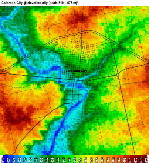
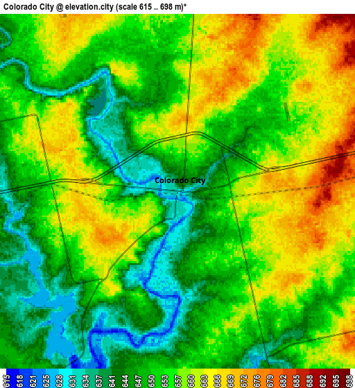
Below is the Elevation map of Colorado City, which displays elevation range with different colors. Scale of the first map is from 619 to 678 m (2031 to 2224 ft) with average elevation of 649.2 meters (=2130 ft) [note 1]
These maps also provides idea of topography and contour of this city, they are displayed at different zoom levels. More info about maps, scale and edge coordinates you can find below images.
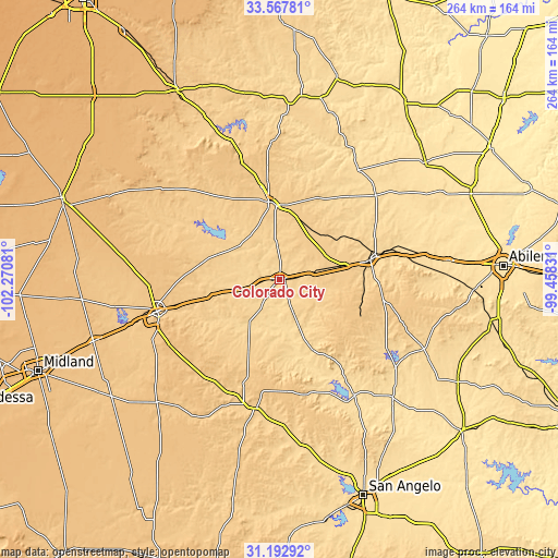
| \ | Map #1 | Map #2 | Topo.Map |
| Scale [m] | 619..678 m | 615..698 m | × |
| Scale [ft] | 2031..2224 ft | 2018..2290 ft | × |
| Average | 649.2 m = 2130 ft | 653.3 m = 2143 ft | × |
| Width | 8.25 km = 5.1 mi | 16.5 km = 10.3 mi | 264.1 km = 164.1 mi |
| Height | 8.25 km = 5.1 mi | 16.5 km = 10.3 mi | 264.1 km = 164.1 mi |
| ↑Max Latitude | 32.425271° | 32.462358° | 33.56781° |
| Latitude at center | 32.38817° | 32.38817° | 32.38817° |
| ↓Min Latitude | 32.351053° | 32.313921° | 31.19292° |
| ← Min Longitude | -100.908505° | -100.952451° | -102.27081° |
| Longitude center | -100.86456° | -100.86456° | -100.86456° |
| →Max Longitude | -100.820615° | -100.776669° | -99.45831° |
Nearby cities:
Cities around Colorado City sort by population:
• Big Spring elevation 747 m
59.7 km,  255°
255°
• Snyder 709 m
37 km,  352°
352°
• Sweetwater 664 m
44 km,  77°
77°
• Merkel 572 m
80.5 km, 83°
• Hamlin 524 m
88.5 km,  51°
51°
• Rotan 595 m
63.7 km,  35°
35°
• Roscoe 728 m
31.3 km, 78°
• Sterling City 696 m
62.4 km,  190°
190°
• Robert Lee 557 m
65.7 km,  147°
147°
• Roby 600 m
60.5 km, 49°
• Garden City 805 m
82.3 km,  224°
224°
• Gail 779 m
69 km,  307°
307°
Multilingual:
 En español:
Colorado City elevación 629 m.
 En France:
Colorado City élévation 629 m.
 Auf Deutsch:
Colorado City höhe über dem Meeresspiegel ist 629 m.

Sources and notes:
- [note 1] Map square and city borders are not equal. Map elevation data is calculated only from area inside that square.
- [src 1] Elevation data from geonames database provided with same terms of usage.
- [src 2] The elevation map of Colorado City is generated using elevation data from NASA's 3 arcsec (90m) resolution SRTM data.
- [src 3] Base (background) map © OpenStreetMap contributors tiles are generated by Geofabrik and OpenTopoMap.
Copyright & License:
This Colorado City Elevation Map is licensed under CC BY-SA. You may reuse any part from this page, if you give a proper credit by linking to this URL:
 More info on terms of use page.