Fort Stockton elevation
Fort Stockton (Texas, Pecos County), United States elevation is 904 meters and Fort Stockton elevation in feet is 2966 ft above sea level [src 1]. Fort Stockton is a seat of a second-order administrative division (feature code) with elevation that is 625 meters (2051 ft) bigger than average city elevation in United States.
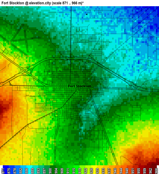
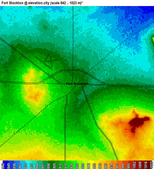
Below is the Elevation map of Fort Stockton, which displays elevation range with different colors. Scale of the first map is from 871 to 966 m (2858 to 3169 ft) with average elevation of 907.3 meters (=2977 ft) [note 1]
These maps also provides idea of topography and contour of this city, they are displayed at different zoom levels. More info about maps, scale and edge coordinates you can find below images.
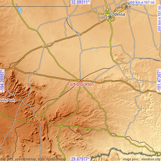
| \ | Map #1 | Map #2 | Topo.Map |
| Scale [m] | 871..966 m | 842..1023 m | × |
| Scale [ft] | 2858..3169 ft | 2762..3356 ft | × |
| Average | 907.3 m = 2977 ft | 909.4 m = 2984 ft | × |
| Width | 8.39 km = 5.2 mi | 16.77 km = 10.4 mi | 268.3 km = 166.7 mi |
| Height | 8.39 km = 5.2 mi | 16.77 km = 10.4 mi | 268.3 km = 166.7 mi |
| ↑Max Latitude | 30.931743° | 30.969431° | 32.09311° |
| Latitude at center | 30.89404° | 30.89404° | 30.89404° |
| ↓Min Latitude | 30.856322° | 30.81859° | 29.67977° |
| ← Min Longitude | -102.923265° | -102.967211° | -104.28557° |
| Longitude center | -102.87932° | -102.87932° | -102.87932° |
| →Max Longitude | -102.835375° | -102.791429° | -101.47307° |
Nearby cities:
Cities around Fort Stockton sort by population:
• West Odessa elevation 902 m
111.5 km,  18°
18°
• Pecos 791 m
82.9 km,  315°
315°
• Monahans 800 m
77.9 km,  359°
359°
• Kermit 875 m
109 km,  349°
349°
• Alpine 1367 m
95.7 km,  231°
231°
• Crane 784 m
75.3 km,  41°
41°
• McCamey 750 m
68 km,  66°
66°
• Iraan 678 m
93.7 km,  88°
88°
• Fort Davis 1494 m
102.8 km,  250°
250°
• Wink 852 m
99 km,  344°
344°
• Rankin 764 m
96.8 km, 67°
• Sanderson 849 m
95.6 km,  150°
150°
Multilingual:
 En español:
Fort Stockton elevación 904 m.
 En France:
Fort Stockton élévation 904 m.
 Auf Deutsch:
Fort Stockton höhe über dem Meeresspiegel ist 904 m.

Sources and notes:
- [note 1] Map square and city borders are not equal. Map elevation data is calculated only from area inside that square.
- [src 1] Elevation data from geonames database provided with same terms of usage.
- [src 2] The elevation map of Fort Stockton is generated using elevation data from NASA's 3 arcsec (90m) resolution SRTM data.
- [src 3] Base (background) map © OpenStreetMap contributors tiles are generated by Geofabrik and OpenTopoMap.
Copyright & License:
This Fort Stockton Elevation Map is licensed under CC BY-SA. You may reuse any part from this page, if you give a proper credit by linking to this URL:
 More info on terms of use page.