Pecos elevation
Pecos (Texas, Reeves County), United States elevation is 791 meters and Pecos elevation in feet is 2595 ft above sea level [src 1]. Pecos is a seat of a second-order administrative division (feature code) with elevation that is 512 meters (1680 ft) bigger than average city elevation in United States.
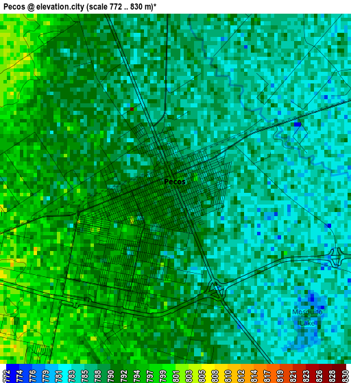
Below is the Elevation map of Pecos, which displays elevation range with different colors. Scale of the first map is from 772 to 830 m (2533 to 2723 ft) with average elevation of 789.4 meters (=2590 ft) [note 1]
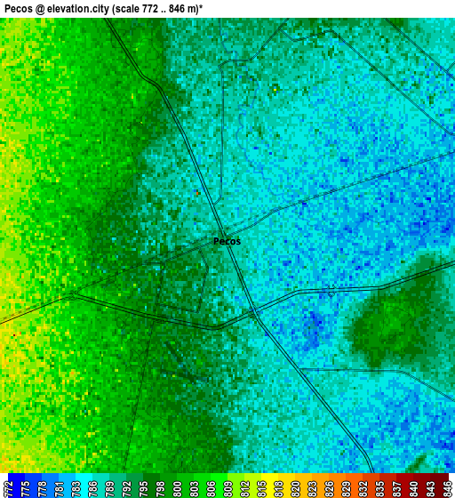
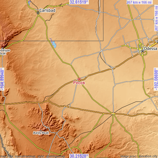
These maps also provides idea of topography and contour of this city, they are displayed at different zoom levels. More info about maps, scale and edge coordinates you can find below images.
| \ | Map #1 | Map #2 | Topo.Map |
| Scale [m] | 772..830 m | 772..846 m | × |
| Scale [ft] | 2533..2723 ft | 2533..2776 ft | × |
| Average | 789.4 m = 2590 ft | 793.6 m = 2604 ft | × |
| Width | 8.34 km = 5.2 mi | 16.68 km = 10.4 mi | 266.8 km = 165.8 mi |
| Height | 8.34 km = 5.2 mi | 16.68 km = 10.4 mi | 266.9 km = 165.8 mi |
| ↑Max Latitude | 31.460403° | 31.497881° | 32.61519° |
| Latitude at center | 31.42291° | 31.42291° | 31.42291° |
| ↓Min Latitude | 31.385402° | 31.347879° | 30.21528° |
| ← Min Longitude | -103.537175° | -103.581121° | -104.89948° |
| Longitude center | -103.49323° | -103.49323° | -103.49323° |
| →Max Longitude | -103.449285° | -103.405339° | -102.08698° |
Nearby cities:
Cities around Pecos sort by population:
• Odessa elevation 885 m
116.5 km,  66°
66°
• West Odessa 902 m
105.1 km,  63°
63°
• Fort Stockton 904 m
82.9 km,  135°
135°
• Monahans 800 m
60 km, 71°
• Kermit 875 m
61.4 km,  38°
38°
• Crane 784 m
108.5 km,  91°
91°
• Eunice 1051 m
117.1 km,  15°
15°
• Jal 939 m
81.8 km, 20°
• Loving 933 m
111.6 km,  329°
329°
• Fort Davis 1494 m
100.4 km,  202°
202°
• Wink 852 m
48.3 km, 40°
• Mentone 825 m
33 km,  342°
342°
Multilingual:
 En español:
Pecos elevación 791 m.
 En France:
Pecos élévation 791 m.


Sources and notes:
- [note 1] Map square and city borders are not equal. Map elevation data is calculated only from area inside that square.
- [src 1] Elevation data from geonames database provided with same terms of usage.
- [src 2] The elevation map of Pecos is generated using elevation data from NASA's 3 arcsec (90m) resolution SRTM data.
- [src 3] Base (background) map © OpenStreetMap contributors tiles are generated by Geofabrik and OpenTopoMap.
Copyright & License:
This Pecos Elevation Map is licensed under CC BY-SA. You may reuse any part from this page, if you give a proper credit by linking to this URL:
 More info on terms of use page.