Goldfield elevation
Goldfield (Nevada, Esmeralda County), United States elevation is 1738 meters and Goldfield elevation in feet is 5702 ft above sea level [src 1]. Goldfield is a seat of a second-order administrative division (feature code) with elevation that is 1459 meters (4787 ft) bigger than average city elevation in United States.
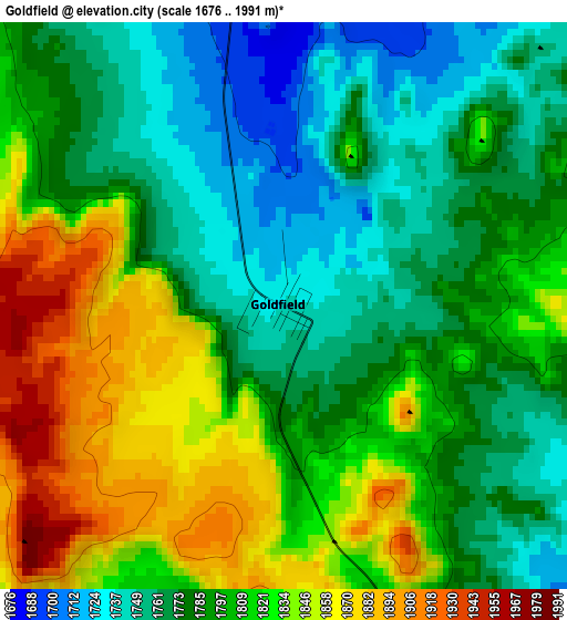
Below is the Elevation map of Goldfield, which displays elevation range with different colors. Scale of the first map is from 1676 to 1991 m (5499 to 6532 ft) with average elevation of 1800 meters (=5906 ft) [note 1]
These maps also provides idea of topography and contour of this city, they are displayed at different zoom levels. More info about maps, scale and edge coordinates you can find below images.
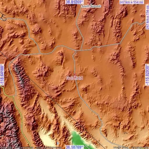
| \ | Map #1 | Topo.Map |
| Scale [m] | 1676..1991 m | × |
| Scale [ft] | 5499..6532 ft | × |
| Average | 1800 m = 5906 ft | × |
| Width | 7.73 km = 4.8 mi | 247.4 km = 153.7 mi |
| Height | 7.73 km = 4.8 mi | 247.4 km = 153.7 mi |
| ↑Max Latitude | 37.743298° | 38.81269° |
| Latitude at center | 37.70854° | 37.70854° |
| ↓Min Latitude | 37.673765° | 36.58769° |
| ← Min Longitude | -117.279575° | -118.64188° |
| Longitude center | -117.23563° | -117.23563° |
| →Max Longitude | -117.191685° | -115.82938° |
Nearby cities:
Cities around Goldfield sort by population:
• Pahrump elevation 823 m
200.5 km,  146°
146°
• Mammoth Lakes 2400 m
153 km,  267°
267°
• Bishop 1265 m
109.2 km,  249°
249°
• Hawthorne 1323 m
151.6 km,  306°
306°
• Dixon Lane-Meadow Creek 1274 m
110 km, 250°
• West Bishop 1340 m
114.3 km, 250°
• Tonopah 1847 m
39.9 km,  0°
0°
• Lone Pine 1138 m
142.9 km,  210°
210°
• Big Pine 1218 m
111 km,  236°
236°
• Alamo 1057 m
186.6 km,  101°
101°
• Beatty 1011 m
98.4 km, 154°
• Bridgeport 1975 m
185.2 km,  289°
289°
Multilingual:
 En español:
Goldfield elevación 1738 m.
 En France:
Goldfield élévation 1738 m.
 Auf Deutsch:
Goldfield höhe über dem Meeresspiegel ist 1738 m.

Sources and notes:
- [note 1] Map square and city borders are not equal. Map elevation data is calculated only from area inside that square.
- [src 1] Elevation data from geonames database provided with same terms of usage.
- [src 2] The elevation map of Goldfield is generated using elevation data from NASA's 3 arcsec (90m) resolution SRTM data.
- [src 3] Base (background) map © OpenStreetMap contributors tiles are generated by Geofabrik and OpenTopoMap.
Copyright & License:
This Goldfield Elevation Map is licensed under CC BY-SA. You may reuse any part from this page, if you give a proper credit by linking to this URL:
 More info on terms of use page.