Lone Pine elevation
Lone Pine (California, Inyo County), United States elevation is 1138 meters and Lone Pine elevation in feet is 3734 ft above sea level [src 1]. Lone Pine is a populated place (feature code) with elevation that is 859 meters (2818 ft) bigger than average city elevation in United States.
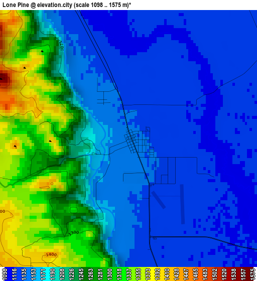
Below is the Elevation map of Lone Pine, which displays elevation range with different colors. Scale of the first map is from 1098 to 1575 m (3602 to 5167 ft) with average elevation of 1192.1 meters (=3911 ft) [note 1]
These maps also provides idea of topography and contour of this city, they are displayed at different zoom levels. More info about maps, scale and edge coordinates you can find below images.
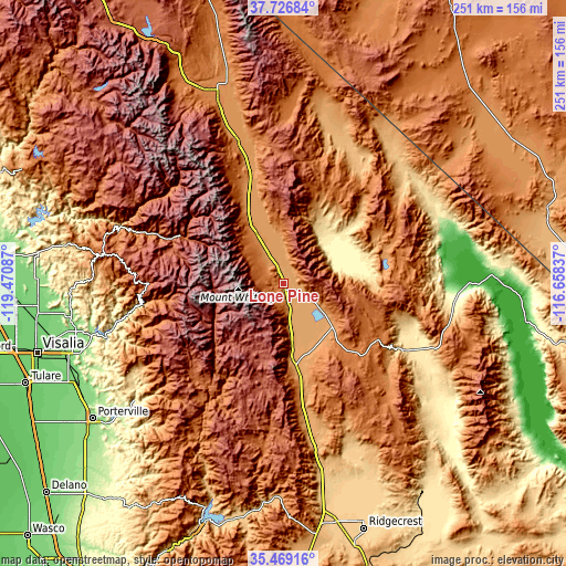
| \ | Map #1 | Topo.Map |
| Scale [m] | 1098..1575 m | × |
| Scale [ft] | 3602..5167 ft | × |
| Average | 1192.1 m = 3911 ft | × |
| Width | 7.84 km = 4.9 mi | 251 km = 156 mi |
| Height | 7.84 km = 4.9 mi | 251 km = 156 mi |
| ↑Max Latitude | 36.641529° | 37.72684° |
| Latitude at center | 36.60626° | 36.60626° |
| ↓Min Latitude | 36.570975° | 35.46916° |
| ← Min Longitude | -118.108565° | -119.47087° |
| Longitude center | -118.06462° | -118.06462° |
| →Max Longitude | -118.020675° | -116.65837° |
Nearby cities:
Cities around Lone Pine sort by population:
• Porterville elevation 144 m
104.4 km,  234°
234°
• Lindsay 121 m
102 km,  243°
243°
• Exeter 122 m
102.3 km,  250°
250°
• Woodlake 137 m
94.9 km,  256°
256°
• East Porterville 151 m
101.9 km, 233°
• Bishop 1265 m
89.2 km,  340°
340°
• Strathmore 125 m
102.8 km, 240°
• Dixon Lane-Meadow Creek 1274 m
92.2 km, 340°
• West Bishop 1340 m
90.8 km, 337°
• Three Rivers 267 m
77.3 km, 256°
• Big Pine 1218 m
65.3 km, 342°
• Kernville 811 m
100.1 km,  198°
198°
Multilingual:
 En español:
Lone Pine elevación 1138 m.
 En France:
Lone Pine élévation 1138 m.
 Auf Deutsch:
Lone Pine höhe über dem Meeresspiegel ist 1138 m.

Sources and notes:
- [note 1] Map square and city borders are not equal. Map elevation data is calculated only from area inside that square.
- [src 1] Elevation data from geonames database provided with same terms of usage.
- [src 2] The elevation map of Lone Pine is generated using elevation data from NASA's 3 arcsec (90m) resolution SRTM data.
- [src 3] Base (background) map © OpenStreetMap contributors tiles are generated by Geofabrik and OpenTopoMap.
Copyright & License:
This Lone Pine Elevation Map is licensed under CC BY-SA. You may reuse any part from this page, if you give a proper credit by linking to this URL:
 More info on terms of use page.