Beatty elevation
Beatty (Nevada, Nye County), United States elevation is 1011 meters and Beatty elevation in feet is 3317 ft above sea level [src 1]. Beatty is a populated place (feature code) with elevation that is 732 meters (2402 ft) bigger than average city elevation in United States.
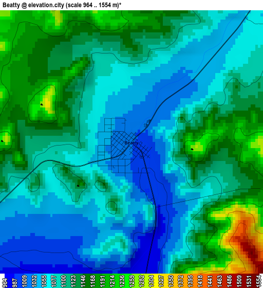
Below is the Elevation map of Beatty, which displays elevation range with different colors. Scale of the first map is from 964 to 1554 m (3163 to 5098 ft) with average elevation of 1105.1 meters (=3626 ft) [note 1]
These maps also provides idea of topography and contour of this city, they are displayed at different zoom levels. More info about maps, scale and edge coordinates you can find below images.
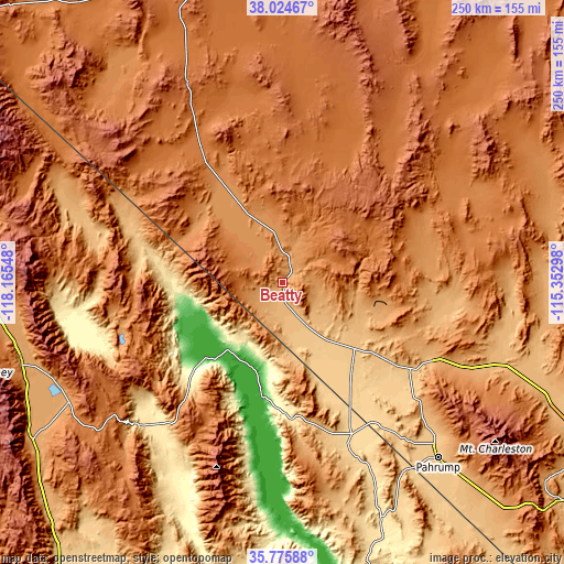
| \ | Map #1 | Topo.Map |
| Scale [m] | 964..1554 m | × |
| Scale [ft] | 3163..5098 ft | × |
| Average | 1105.1 m = 3626 ft | × |
| Width | 7.81 km = 4.9 mi | 250 km = 155.3 mi |
| Height | 7.81 km = 4.9 mi | 250 km = 155.3 mi |
| ↑Max Latitude | 36.94369° | 38.02467° |
| Latitude at center | 36.90856° | 36.90856° |
| ↓Min Latitude | 36.873413° | 35.77588° |
| ← Min Longitude | -116.803175° | -118.16548° |
| Longitude center | -116.75923° | -116.75923° |
| →Max Longitude | -116.715285° | -115.35298° |
Nearby cities:
Cities around Beatty sort by population:
• Pahrump elevation 823 m
104.2 km,  138°
138°
• Summerlin South 872 m
155.1 km,  124°
124°
• Bishop 1265 m
153.6 km,  289°
289°
• Dixon Lane-Meadow Creek 1274 m
156.1 km, 289°
• West Bishop 1340 m
158.5 km, 288°
• Tonopah 1847 m
135.4 km,  342°
342°
• Sandy Valley 806 m
157.8 km, 140°
• Lone Pine 1138 m
121 km,  253°
253°
• Big Pine 1218 m
138.8 km,  281°
281°
• Searles Valley 630 m
139.4 km,  204°
204°
• Alamo 1057 m
150.2 km,  70°
70°
• Goldfield 1738 m
98.4 km,  334°
334°
Multilingual:
 En español:
Beatty elevación 1011 m.
 En France:
Beatty élévation 1011 m.


Sources and notes:
- [note 1] Map square and city borders are not equal. Map elevation data is calculated only from area inside that square.
- [src 1] Elevation data from geonames database provided with same terms of usage.
- [src 2] The elevation map of Beatty is generated using elevation data from NASA's 3 arcsec (90m) resolution SRTM data.
- [src 3] Base (background) map © OpenStreetMap contributors tiles are generated by Geofabrik and OpenTopoMap.
Copyright & License:
This Beatty Elevation Map is licensed under CC BY-SA. You may reuse any part from this page, if you give a proper credit by linking to this URL:
 More info on terms of use page.