Bridgeport elevation
Bridgeport (California, Mono County), United States elevation is 1975 meters and Bridgeport elevation in feet is 6480 ft above sea level [src 1]. Bridgeport is a seat of a second-order administrative division (feature code) with elevation that is 1696 meters (5564 ft) bigger than average city elevation in United States.
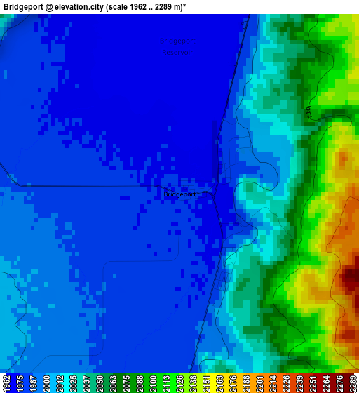
Below is the Elevation map of Bridgeport, which displays elevation range with different colors. Scale of the first map is from 1962 to 2289 m (6437 to 7510 ft) with average elevation of 2016.4 meters (=6615 ft) [note 1]
These maps also provides idea of topography and contour of this city, they are displayed at different zoom levels. More info about maps, scale and edge coordinates you can find below images.
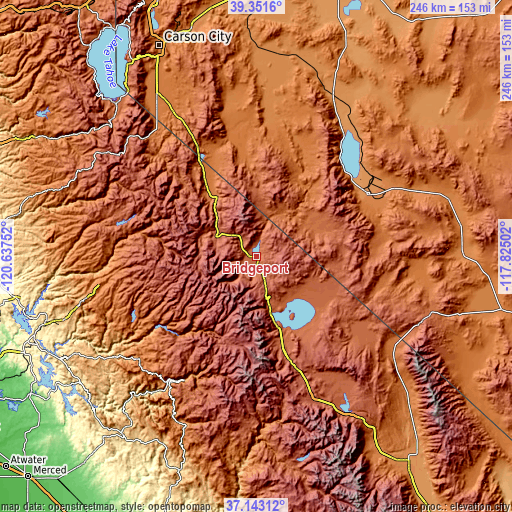
| \ | Map #1 | Topo.Map |
| Scale [m] | 1962..2289 m | × |
| Scale [ft] | 6437..7510 ft | × |
| Average | 2016.4 m = 6615 ft | × |
| Width | 7.67 km = 4.8 mi | 245.6 km = 152.6 mi |
| Height | 7.67 km = 4.8 mi | 245.6 km = 152.6 mi |
| ↑Max Latitude | 38.29025° | 39.3516° |
| Latitude at center | 38.25575° | 38.25575° |
| ↓Min Latitude | 38.221234° | 37.14312° |
| ← Min Longitude | -119.275215° | -120.63752° |
| Longitude center | -119.23127° | -119.23127° |
| →Max Longitude | -119.187325° | -117.82502° |
Nearby cities:
Cities around Bridgeport sort by population:
• Gardnerville Ranchos elevation 1487 m
83.1 km,  327°
327°
• Mammoth Lakes 2400 m
71.2 km,  161°
161°
• Gardnerville 1452 m
88.5 km, 329°
• Hawthorne 1323 m
60.7 km,  60°
60°
• Yerington 1342 m
81.4 km,  4°
4°
• Minden 1449 m
90.5 km, 329°
• Twain Harte 1125 m
90.8 km,  254°
254°
• Smith Valley 1471 m
59.6 km,  350°
350°
• Topaz Ranch Estates 1561 m
58.3 km,  336°
336°
• East Valley 1499 m
86.6 km, 331°
• Yosemite Valley 1227 m
64.8 km,  207°
207°
• Smith 1459 m
61.1 km, 352°
Multilingual:
 En español:
Bridgeport elevación 1975 m.
 En France:
Bridgeport élévation 1975 m.
 Auf Deutsch:
Bridgeport höhe über dem Meeresspiegel ist 1975 m.

Sources and notes:
- [note 1] Map square and city borders are not equal. Map elevation data is calculated only from area inside that square.
- [src 1] Elevation data from geonames database provided with same terms of usage.
- [src 2] The elevation map of Bridgeport is generated using elevation data from NASA's 3 arcsec (90m) resolution SRTM data.
- [src 3] Base (background) map © OpenStreetMap contributors tiles are generated by Geofabrik and OpenTopoMap.
Copyright & License:
This Bridgeport Elevation Map is licensed under CC BY-SA. You may reuse any part from this page, if you give a proper credit by linking to this URL:
 More info on terms of use page.