Mammoth Lakes elevation
Mammoth Lakes (California, Mono County), United States elevation is 2400 meters and Mammoth Lakes elevation in feet is 7874 ft above sea level [src 1]. Mammoth Lakes is a populated place (feature code) with elevation that is 2121 meters (6959 ft) bigger than average city elevation in United States.
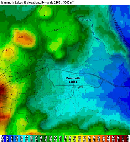
Below is the Elevation map of Mammoth Lakes, which displays elevation range with different colors. Scale of the first map is from 2263 to 3040 m (7425 to 9974 ft) with average elevation of 2497 meters (=8192 ft) [note 1]
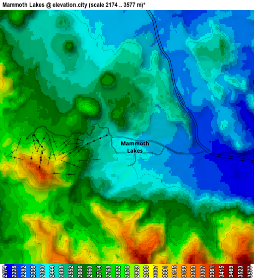
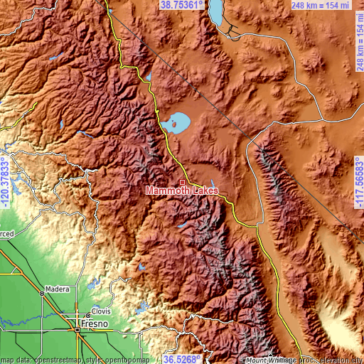
These maps also provides idea of topography and contour of this city, they are displayed at different zoom levels. More info about maps, scale and edge coordinates you can find below images.
| \ | Map #1 | Map #2 | Topo.Map |
| Scale [m] | 2263..3040 m | 2174..3577 m | × |
| Scale [ft] | 7425..9974 ft | 7133..11736 ft | × |
| Average | 2497 m = 8192 ft | 2595.1 m = 8514 ft | × |
| Width | 7.74 km = 4.8 mi | 15.48 km = 9.6 mi | 247.6 km = 153.9 mi |
| Height | 7.74 km = 4.8 mi | 15.48 km = 9.6 mi | 247.6 km = 153.9 mi |
| ↑Max Latitude | 37.683337° | 37.718107° | 38.75361° |
| Latitude at center | 37.64855° | 37.64855° | 37.64855° |
| ↓Min Latitude | 37.613747° | 37.578928° | 36.5268° |
| ← Min Longitude | -119.016025° | -119.059971° | -120.37833° |
| Longitude center | -118.97208° | -118.97208° | -118.97208° |
| →Max Longitude | -118.928135° | -118.884189° | -117.56583° |
Nearby cities:
Cities around Mammoth Lakes sort by population:
• Yosemite Lakes elevation 393 m
87.1 km,  234°
234°
• Bishop 1265 m
60 km,  121°
121°
• Oakhurst 697 m
69.6 km,  239°
239°
• Dixon Lane-Meadow Creek 1274 m
57.1 km, 120°
• West Bishop 1340 m
55.7 km,  125°
125°
• Auberry 620 m
77.7 km,  215°
215°
• Ahwahnee 720 m
73.6 km, 244°
• Coarsegold 681 m
77.4 km, 236°
• Big Pine 1218 m
80.8 km, 131°
• Midpines 799 m
84.3 km,  262°
262°
• Yosemite Valley 1227 m
54.3 km,  280°
280°
• Bridgeport 1975 m
71.2 km,  341°
341°
Multilingual:
 En español:
Mammoth Lakes elevación 2400 m.
 En France:
Mammoth Lakes élévation 2400 m.
 Auf Deutsch:
Mammoth Lakes höhe über dem Meeresspiegel ist 2400 m.

Sources and notes:
- [note 1] Map square and city borders are not equal. Map elevation data is calculated only from area inside that square.
- [src 1] Elevation data from geonames database provided with same terms of usage.
- [src 2] The elevation map of Mammoth Lakes is generated using elevation data from NASA's 3 arcsec (90m) resolution SRTM data.
- [src 3] Base (background) map © OpenStreetMap contributors tiles are generated by Geofabrik and OpenTopoMap.
Copyright & License:
This Mammoth Lakes Elevation Map is licensed under CC BY-SA. You may reuse any part from this page, if you give a proper credit by linking to this URL:
 More info on terms of use page.