Auberry elevation
Auberry (California, Fresno County), United States elevation is 620 meters and Auberry elevation in feet is 2034 ft above sea level [src 1]. Auberry is a populated place (feature code) with elevation that is 341 meters (1119 ft) bigger than average city elevation in United States.
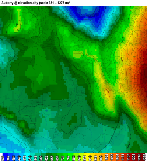
Below is the Elevation map of Auberry, which displays elevation range with different colors. Scale of the first map is from 331 to 1276 m (1086 to 4186 ft) with average elevation of 680.3 meters (=2232 ft) [note 1]
These maps also provides idea of topography and contour of this city, they are displayed at different zoom levels. More info about maps, scale and edge coordinates you can find below images.
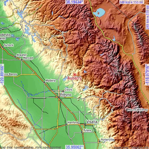
| \ | Map #1 | Topo.Map |
| Scale [m] | 331..1276 m | × |
| Scale [ft] | 1086..4186 ft | × |
| Average | 680.3 m = 2232 ft | × |
| Width | 7.8 km = 4.8 mi | 249.5 km = 155 mi |
| Height | 7.8 km = 4.8 mi | 249.5 km = 155 mi |
| ↑Max Latitude | 37.115831° | 38.19434° |
| Latitude at center | 37.08078° | 37.08078° |
| ↓Min Latitude | 37.045713° | 35.95062° |
| ← Min Longitude | -119.529355° | -120.89166° |
| Longitude center | -119.48541° | -119.48541° |
| →Max Longitude | -119.441465° | -118.07916° |
Nearby cities:
Cities around Auberry sort by population:
• Clovis elevation 113 m
34.4 km,  214°
214°
• Sanger 115 m
41.9 km,  188°
188°
• Bonadelle Ranchos-Madera Ranchos 116 m
36.2 km,  252°
252°
• Old Fig Garden 100 m
42.3 km,  222°
222°
• Yosemite Lakes 393 m
28.3 km,  295°
295°
• Sunnyside 101 m
41.5 km, 207°
• Tarpey Village 111 m
37.3 km, 210°
• Squaw Valley 499 m
43.4 km,  150°
150°
• Oakhurst 697 m
31.1 km,  332°
332°
• Ahwahnee 720 m
38.2 km, 326°
• Coarsegold 681 m
27.8 km,  316°
316°
• Minkler 127 m
39.8 km,  176°
176°
Multilingual:
 En español:
Auberry elevación 620 m.
 En France:
Auberry élévation 620 m.


Sources and notes:
- [note 1] Map square and city borders are not equal. Map elevation data is calculated only from area inside that square.
- [src 1] Elevation data from geonames database provided with same terms of usage.
- [src 2] The elevation map of Auberry is generated using elevation data from NASA's 3 arcsec (90m) resolution SRTM data.
- [src 3] Base (background) map © OpenStreetMap contributors tiles are generated by Geofabrik and OpenTopoMap.
Copyright & License:
This Auberry Elevation Map is licensed under CC BY-SA. You may reuse any part from this page, if you give a proper credit by linking to this URL:
 More info on terms of use page.