Coarsegold elevation
Coarsegold (California, Madera County), United States elevation is 681 meters and Coarsegold elevation in feet is 2234 ft above sea level [src 1]. Coarsegold is a populated place (feature code) with elevation that is 402 meters (1319 ft) bigger than average city elevation in United States.
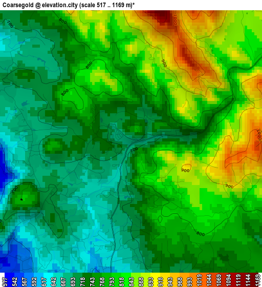
Below is the Elevation map of Coarsegold, which displays elevation range with different colors. Scale of the first map is from 517 to 1169 m (1696 to 3835 ft) with average elevation of 768.8 meters (=2522 ft) [note 1]
These maps also provides idea of topography and contour of this city, they are displayed at different zoom levels. More info about maps, scale and edge coordinates you can find below images.
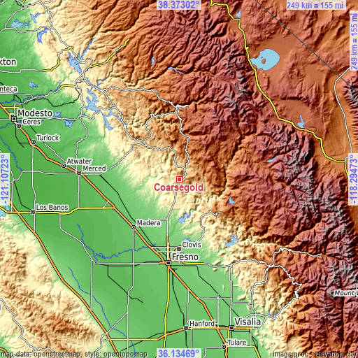
| \ | Map #1 | Topo.Map |
| Scale [m] | 517..1169 m | × |
| Scale [ft] | 1696..3835 ft | × |
| Average | 768.8 m = 2522 ft | × |
| Width | 7.78 km = 4.8 mi | 248.9 km = 154.7 mi |
| Height | 7.78 km = 4.8 mi | 248.9 km = 154.7 mi |
| ↑Max Latitude | 37.297137° | 38.37302° |
| Latitude at center | 37.26217° | 37.26217° |
| ↓Min Latitude | 37.227187° | 36.13469° |
| ← Min Longitude | -119.744925° | -121.10723° |
| Longitude center | -119.70098° | -119.70098° |
| →Max Longitude | -119.657035° | -118.29473° |
Nearby cities:
Cities around Coarsegold sort by population:
• Madera elevation 87 m
46.2 km,  223°
223°
• Madera Acres 88 m
42.2 km,  230°
230°
• Bonadelle Ranchos-Madera Ranchos 116 m
34.5 km,  206°
206°
• Yosemite Lakes 393 m
10.1 km, 218°
• Oakhurst 697 m
8.6 km,  31°
31°
• Parksdale 86 m
45.2 km, 219°
• Auberry 620 m
27.8 km,  136°
136°
• Parkwood 83 m
48.2 km, 219°
• Ahwahnee 720 m
11.7 km,  348°
348°
• Mariposa 590 m
34.1 km,  316°
316°
• Fairmead 77 m
48.2 km,  244°
244°
• Midpines 799 m
36.9 km,  328°
328°
Multilingual:
 En español:
Coarsegold elevación 681 m.
 En France:
Coarsegold élévation 681 m.
 Auf Deutsch:
Coarsegold höhe über dem Meeresspiegel ist 681 m.

Sources and notes:
- [note 1] Map square and city borders are not equal. Map elevation data is calculated only from area inside that square.
- [src 1] Elevation data from geonames database provided with same terms of usage.
- [src 2] The elevation map of Coarsegold is generated using elevation data from NASA's 3 arcsec (90m) resolution SRTM data.
- [src 3] Base (background) map © OpenStreetMap contributors tiles are generated by Geofabrik and OpenTopoMap.
Copyright & License:
This Coarsegold Elevation Map is licensed under CC BY-SA. You may reuse any part from this page, if you give a proper credit by linking to this URL:
 More info on terms of use page.