Conejos elevation
Conejos (Colorado, Conejos County), United States elevation is 2413 meters and Conejos elevation in feet is 7917 ft above sea level [src 1]. Conejos is a seat of a second-order administrative division (feature code) with elevation that is 2134 meters (7001 ft) bigger than average city elevation in United States.
Below is the Elevation map of Conejos, which displays elevation range with different colors. Scale of the first map is from 2374 to 2463 m (7789 to 8081 ft) with average elevation of 2408.3 meters (=7901 ft) [note 1]
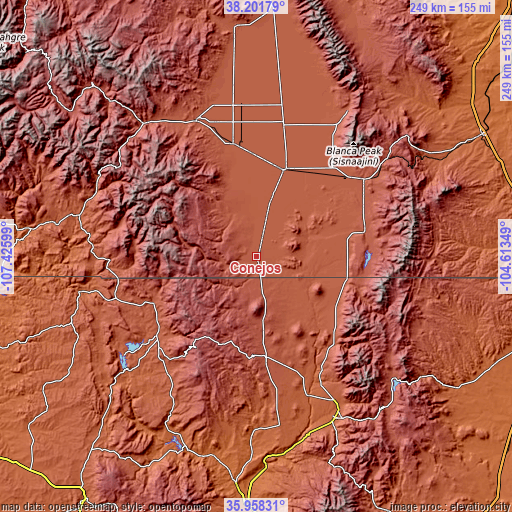
These maps also provides idea of topography and contour of this city, they are displayed at different zoom levels. More info about maps, scale and edge coordinates you can find below images.
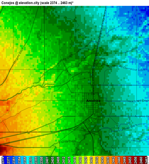
| \ | Map #1 | Topo.Map |
| Scale [m] | 2374..2463 m | × |
| Scale [ft] | 7789..8081 ft | × |
| Average | 2408.3 m = 7901 ft | × |
| Width | 7.8 km = 4.8 mi | 249.5 km = 155 mi |
| Height | 7.8 km = 4.8 mi | 249.5 km = 155 mi |
| ↑Max Latitude | 37.123397° | 38.20179° |
| Latitude at center | 37.08835° | 37.08835° |
| ↓Min Latitude | 37.053286° | 35.95831° |
| ← Min Longitude | -106.063685° | -107.42599° |
| Longitude center | -106.01974° | -106.01974° |
| →Max Longitude | -105.975795° | -104.61349° |
Nearby cities:
Cities around Conejos sort by population:
• Alamosa elevation 2303 m
44.4 km,  17°
17°
• Taos 2123 m
85.6 km,  152°
152°
• Monte Vista 2341 m
55.7 km,  348°
348°
• Center 2333 m
74.3 km, 353°
• Arroyo Seco 2328 m
75.2 km, 147°
• Questa 2274 m
57 km,  138°
138°
• Del Norte 2405 m
72 km,  335°
335°
• Alamosa East 2297 m
46 km, 19°
• Taos Pueblo 2172 m
83.7 km, 149°
• Chama 2396 m
53.8 km,  247°
247°
• San Luis 2433 m
54.3 km,  76°
76°
• Tierra Amarilla 2295 m
63.9 km,  227°
227°
Multilingual:
 En español:
Conejos elevación 2413 m.
 En France:
Conejos élévation 2413 m.
 Auf Deutsch:
Conejos höhe über dem Meeresspiegel ist 2413 m.

Sources and notes:
- [note 1] Map square and city borders are not equal. Map elevation data is calculated only from area inside that square.
- [src 1] Elevation data from geonames database provided with same terms of usage.
- [src 2] The elevation map of Conejos is generated using elevation data from NASA's 3 arcsec (90m) resolution SRTM data.
- [src 3] Base (background) map © OpenStreetMap contributors tiles are generated by Geofabrik and OpenTopoMap.
Copyright & License:
This Conejos Elevation Map is licensed under CC BY-SA. You may reuse any part from this page, if you give a proper credit by linking to this URL:
 More info on terms of use page.