Center elevation
Center (Colorado, Saguache County), United States elevation is 2333 meters and Center elevation in feet is 7654 ft above sea level [src 1]. Center is a populated place (feature code) with elevation that is 2054 meters (6739 ft) bigger than average city elevation in United States.
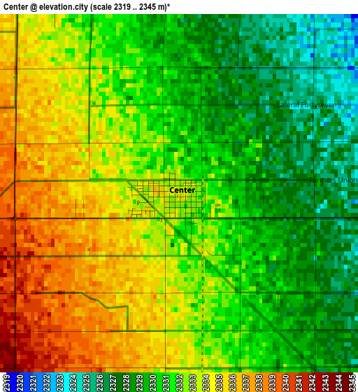
Below is the Elevation map of Center, which displays elevation range with different colors. Scale of the first map is from 2319 to 2345 m (7608 to 7694 ft) with average elevation of 2331.6 meters (=7650 ft) [note 1]
These maps also provides idea of topography and contour of this city, they are displayed at different zoom levels. More info about maps, scale and edge coordinates you can find below images.
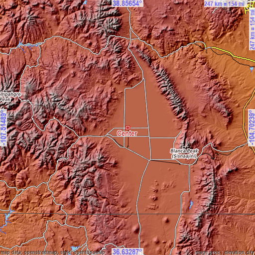
| \ | Map #1 | Topo.Map |
| Scale [m] | 2319..2345 m | × |
| Scale [ft] | 7608..7694 ft | × |
| Average | 2331.6 m = 7650 ft | × |
| Width | 7.73 km = 4.8 mi | 247.2 km = 153.6 mi |
| Height | 7.73 km = 4.8 mi | 247.2 km = 153.6 mi |
| ↑Max Latitude | 37.787798° | 38.85654° |
| Latitude at center | 37.75306° | 37.75306° |
| ↓Min Latitude | 37.718306° | 36.63287° |
| ← Min Longitude | -106.152585° | -107.51489° |
| Longitude center | -106.10864° | -106.10864° |
| →Max Longitude | -106.064695° | -104.70239° |
Nearby cities:
Cities around Center sort by population:
• Alamosa elevation 2303 m
37.9 km,  146°
146°
• Salida 2163 m
87.4 km,  6°
6°
• Monte Vista 2341 m
19.6 km,  190°
190°
• Pagosa Springs 2170 m
96 km,  235°
235°
• Del Norte 2405 m
23.1 km,  249°
249°
• Alamosa East 2297 m
38.6 km,  142°
142°
• Chama 2396 m
103.3 km,  203°
203°
• San Luis 2433 m
86.1 km, 135°
• Westcliffe 2404 m
70.6 km,  53°
53°
• Saguache 2354 m
37.3 km,  355°
355°
• Creede 2693 m
72.6 km,  278°
278°
• Conejos 2413 m
74.3 km,  173°
173°
Multilingual:
 En español:
Center elevación 2333 m.
 En France:
Center élévation 2333 m.


Sources and notes:
- [note 1] Map square and city borders are not equal. Map elevation data is calculated only from area inside that square.
- [src 1] Elevation data from geonames database provided with same terms of usage.
- [src 2] The elevation map of Center is generated using elevation data from NASA's 3 arcsec (90m) resolution SRTM data.
- [src 3] Base (background) map © OpenStreetMap contributors tiles are generated by Geofabrik and OpenTopoMap.
Copyright & License:
This Center Elevation Map is licensed under CC BY-SA. You may reuse any part from this page, if you give a proper credit by linking to this URL:
 More info on terms of use page.