Alamosa elevation
Alamosa (Colorado, Alamosa County), United States elevation is 2303 meters and Alamosa elevation in feet is 7556 ft above sea level [src 1]. Alamosa is a seat of a second-order administrative division (feature code) with elevation that is 2024 meters (6640 ft) bigger than average city elevation in United States.
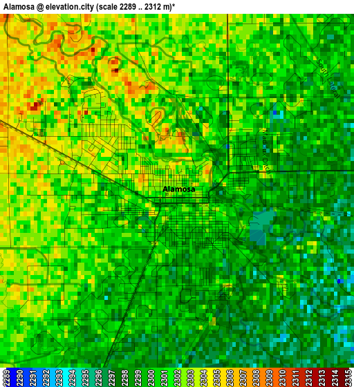
Below is the Elevation map of Alamosa, which displays elevation range with different colors. Scale of the first map is from 2289 to 2312 m (7510 to 7585 ft) with average elevation of 2300.3 meters (=7547 ft) [note 1]
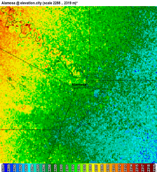
These maps also provides idea of topography and contour of this city, they are displayed at different zoom levels. More info about maps, scale and edge coordinates you can find below images.
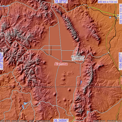
| \ | Map #1 | Map #2 | Topo.Map |
| Scale [m] | 2289..2312 m | 2288..2319 m | × |
| Scale [ft] | 7510..7585 ft | 7507..7608 ft | × |
| Average | 2300.3 m = 7547 ft | 2300.6 m = 7548 ft | × |
| Width | 7.76 km = 4.8 mi | 15.51 km = 9.6 mi | 248.2 km = 154.2 mi |
| Height | 7.76 km = 4.8 mi | 15.51 km = 9.6 mi | 248.2 km = 154.2 mi |
| ↑Max Latitude | 37.50432° | 37.539174° | 38.5772° |
| Latitude at center | 37.46945° | 37.46945° | 37.46945° |
| ↓Min Latitude | 37.434563° | 37.399661° | 36.34504° |
| ← Min Longitude | -105.913965° | -105.957911° | -107.27627° |
| Longitude center | -105.87002° | -105.87002° | -105.87002° |
| →Max Longitude | -105.826075° | -105.782129° | -104.46377° |
Nearby cities:
Cities around Alamosa sort by population:
• Monte Vista elevation 2341 m
27.4 km,  296°
296°
• Walsenburg 1884 m
97.6 km,  79°
79°
• Center 2333 m
37.9 km,  326°
326°
• Questa 2274 m
88.5 km,  164°
164°
• Del Norte 2405 m
48.5 km, 298°
• Alamosa East 2297 m
2.6 km,  70°
70°
• Chama 2396 m
89 km,  224°
224°
• San Luis 2433 m
49.5 km,  127°
127°
• Westcliffe 2404 m
82.1 km,  25°
25°
• Saguache 2354 m
72.8 km,  340°
340°
• Creede 2693 m
102.1 km,  294°
294°
• Conejos 2413 m
44.4 km,  197°
197°
Multilingual:
 En español:
Alamosa elevación 2303 m.
 En France:
Alamosa élévation 2303 m.
 Auf Deutsch:
Alamosa höhe über dem Meeresspiegel ist 2303 m.

Sources and notes:
- [note 1] Map square and city borders are not equal. Map elevation data is calculated only from area inside that square.
- [src 1] Elevation data from geonames database provided with same terms of usage.
- [src 2] The elevation map of Alamosa is generated using elevation data from NASA's 3 arcsec (90m) resolution SRTM data.
- [src 3] Base (background) map © OpenStreetMap contributors tiles are generated by Geofabrik and OpenTopoMap.
Copyright & License:
This Alamosa Elevation Map is licensed under CC BY-SA. You may reuse any part from this page, if you give a proper credit by linking to this URL:
 More info on terms of use page.