Walsenburg elevation
Walsenburg (Colorado, Huerfano County), United States elevation is 1884 meters and Walsenburg elevation in feet is 6181 ft above sea level [src 1]. Walsenburg is a seat of a second-order administrative division (feature code) with elevation that is 1605 meters (5266 ft) bigger than average city elevation in United States.
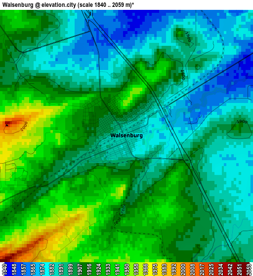
Below is the Elevation map of Walsenburg, which displays elevation range with different colors. Scale of the first map is from 1840 to 2059 m (6037 to 6755 ft) with average elevation of 1907.4 meters (=6258 ft) [note 1]
These maps also provides idea of topography and contour of this city, they are displayed at different zoom levels. More info about maps, scale and edge coordinates you can find below images.
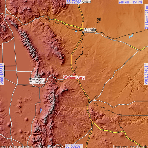
| \ | Map #1 | Topo.Map |
| Scale [m] | 1840..2059 m | × |
| Scale [ft] | 6037..6755 ft | × |
| Average | 1907.4 m = 6258 ft | × |
| Width | 7.74 km = 4.8 mi | 247.7 km = 153.9 mi |
| Height | 7.74 km = 4.8 mi | 247.7 km = 153.9 mi |
| ↑Max Latitude | 37.658978° | 38.7296° |
| Latitude at center | 37.62418° | 37.62418° |
| ↓Min Latitude | 37.589366° | 36.50207° |
| ← Min Longitude | -104.824205° | -106.18651° |
| Longitude center | -104.78026° | -104.78026° |
| →Max Longitude | -104.736315° | -103.37401° |
Nearby cities:
Cities around Walsenburg sort by population:
• Pueblo elevation 1430 m
71.7 km,  12°
12°
• Pueblo West 1548 m
80.9 km,  3°
3°
• Trinidad 1844 m
56.3 km,  153°
153°
• Raton 2034 m
85.6 km,  159°
159°
• Florence 1583 m
90.2 km,  340°
340°
• Penrose 1629 m
91.5 km,  346°
346°
• Lincoln Park 1644 m
97.4 km, 336°
• Colorado City 1788 m
36 km, 352°
• Alamosa East 2297 m
95 km,  260°
260°
• Fowler 1328 m
87 km,  49°
49°
• San Luis 2433 m
73.8 km,  230°
230°
• Westcliffe 2404 m
82.7 km,  313°
313°
Multilingual:
 En español:
Walsenburg elevación 1884 m.
 En France:
Walsenburg élévation 1884 m.
 Auf Deutsch:
Walsenburg höhe über dem Meeresspiegel ist 1884 m.

Sources and notes:
- [note 1] Map square and city borders are not equal. Map elevation data is calculated only from area inside that square.
- [src 1] Elevation data from geonames database provided with same terms of usage.
- [src 2] The elevation map of Walsenburg is generated using elevation data from NASA's 3 arcsec (90m) resolution SRTM data.
- [src 3] Base (background) map © OpenStreetMap contributors tiles are generated by Geofabrik and OpenTopoMap.
Copyright & License:
This Walsenburg Elevation Map is licensed under CC BY-SA. You may reuse any part from this page, if you give a proper credit by linking to this URL:
 More info on terms of use page.