Trinidad elevation
Trinidad (Colorado, Las Animas County), United States elevation is 1844 meters and Trinidad elevation in feet is 6050 ft above sea level [src 1]. Trinidad is a seat of a second-order administrative division (feature code) with elevation that is 1565 meters (5135 ft) bigger than average city elevation in United States.
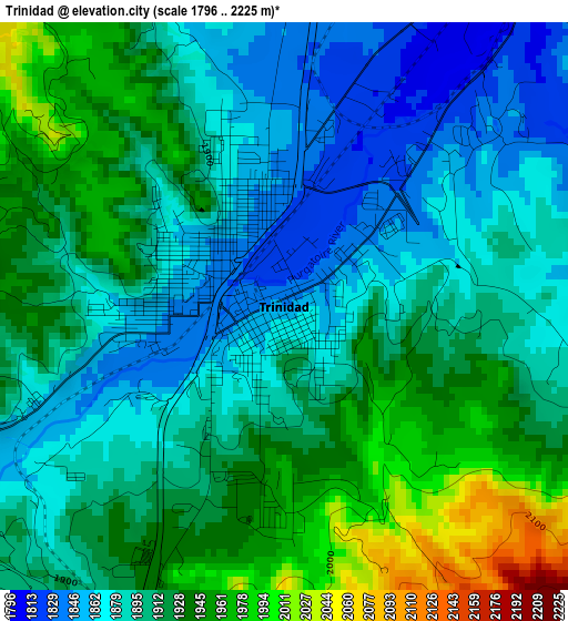
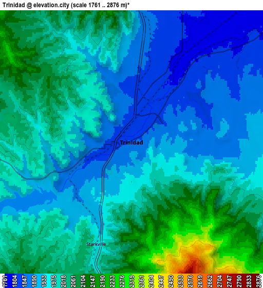
Below is the Elevation map of Trinidad, which displays elevation range with different colors. Scale of the first map is from 1796 to 2225 m (5892 to 7300 ft) with average elevation of 1906.8 meters (=6256 ft) [note 1]
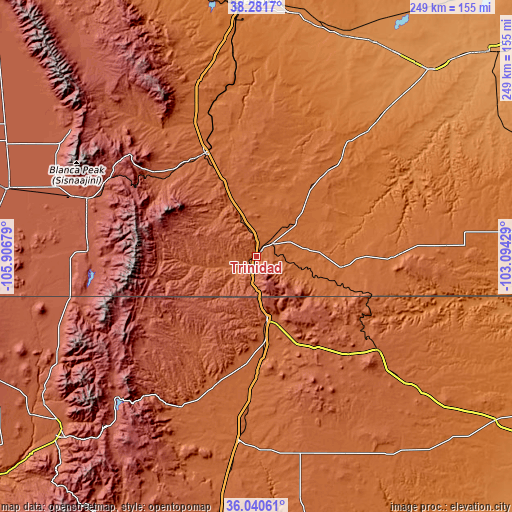
These maps also provides idea of topography and contour of this city, they are displayed at different zoom levels. More info about maps, scale and edge coordinates you can find below images.
| \ | Map #1 | Map #2 | Topo.Map |
| Scale [m] | 1796..2225 m | 1761..2876 m | × |
| Scale [ft] | 5892..7300 ft | 5778..9436 ft | × |
| Average | 1906.8 m = 6256 ft | 1980 m = 6496 ft | × |
| Width | 7.79 km = 4.8 mi | 15.57 km = 9.7 mi | 249.2 km = 154.8 mi |
| Height | 7.79 km = 4.8 mi | 15.57 km = 9.7 mi | 249.2 km = 154.8 mi |
| ↑Max Latitude | 37.20447° | 37.239463° | 38.2817° |
| Latitude at center | 37.16946° | 37.16946° | 37.16946° |
| ↓Min Latitude | 37.134434° | 37.099392° | 36.04061° |
| ← Min Longitude | -104.544485° | -104.588431° | -105.90679° |
| Longitude center | -104.50054° | -104.50054° | -104.50054° |
| →Max Longitude | -104.456595° | -104.412649° | -103.09429° |
Nearby cities:
Cities around Trinidad sort by population:
• Pueblo elevation 1430 m
121 km,  355°
355°
• Raton 2034 m
30.1 km,  169°
169°
• Rocky Ford 1276 m
119.9 km,  34°
34°
• Walsenburg 1884 m
56.3 km,  333°
333°
• Colorado City 1788 m
91.2 km,  341°
341°
• Arroyo Seco 2328 m
119.6 km,  232°
232°
• Questa 2274 m
110.2 km,  241°
241°
• Alamosa East 2297 m
123.5 km,  286°
286°
• Fowler 1328 m
114.7 km,  21°
21°
• Taos Pueblo 2172 m
123.5 km, 228°
• Angel Fire 2566 m
111.1 km,  218°
218°
• San Luis 2433 m
81.9 km,  272°
272°
Multilingual:
 En español:
Trinidad elevación 1844 m.
 En France:
Trinidad élévation 1844 m.
 Auf Deutsch:
Trinidad höhe über dem Meeresspiegel ist 1844 m.

Sources and notes:
- [note 1] Map square and city borders are not equal. Map elevation data is calculated only from area inside that square.
- [src 1] Elevation data from geonames database provided with same terms of usage.
- [src 2] The elevation map of Trinidad is generated using elevation data from NASA's 3 arcsec (90m) resolution SRTM data.
- [src 3] Base (background) map © OpenStreetMap contributors tiles are generated by Geofabrik and OpenTopoMap.
Copyright & License:
This Trinidad Elevation Map is licensed under CC BY-SA. You may reuse any part from this page, if you give a proper credit by linking to this URL:
 More info on terms of use page.