Pagosa Springs elevation
Pagosa Springs (Colorado, Archuleta County), United States elevation is 2170 meters and Pagosa Springs elevation in feet is 7119 ft above sea level [src 1]. Pagosa Springs is a seat of a second-order administrative division (feature code) with elevation that is 1891 meters (6204 ft) bigger than average city elevation in United States.
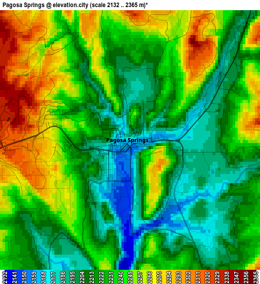
Below is the Elevation map of Pagosa Springs, which displays elevation range with different colors. Scale of the first map is from 2132 to 2365 m (6995 to 7759 ft) with average elevation of 2230.4 meters (=7318 ft) [note 1]
These maps also provides idea of topography and contour of this city, they are displayed at different zoom levels. More info about maps, scale and edge coordinates you can find below images.
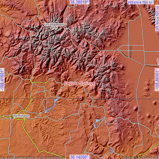
| \ | Map #1 | Topo.Map |
| Scale [m] | 2132..2365 m | × |
| Scale [ft] | 6995..7759 ft | × |
| Average | 2230.4 m = 7318 ft | × |
| Width | 7.78 km = 4.8 mi | 248.9 km = 154.7 mi |
| Height | 7.78 km = 4.8 mi | 248.9 km = 154.7 mi |
| ↑Max Latitude | 37.304413° | 38.38019° |
| Latitude at center | 37.26945° | 37.26945° |
| ↓Min Latitude | 37.23447° | 36.14208° |
| ← Min Longitude | -107.053705° | -108.41601° |
| Longitude center | -107.00976° | -107.00976° |
| →Max Longitude | -106.965815° | -105.60351° |
Nearby cities:
Cities around Pagosa Springs sort by population:
• Durango elevation 1998 m
77 km,  270°
270°
• Monte Vista 2341 m
83.5 km,  65°
65°
• Dulce 2070 m
37.4 km,  178°
178°
• Bayfield 2108 m
52.3 km,  264°
264°
• Navajo 2010 m
36.3 km,  187°
187°
• Del Norte 2405 m
73.7 km,  51°
51°
• Chama 2396 m
55.8 km,  136°
136°
• Silverton 2840 m
83.5 km,  316°
316°
• Creede 2693 m
64.9 km,  6°
6°
• Tierra Amarilla 2295 m
75.3 km,  147°
147°
• Lake City 2651 m
88.7 km,  342°
342°
• Conejos 2413 m
90 km,  102°
102°
Multilingual:
 En español:
Pagosa Springs elevación 2170 m.
 En France:
Pagosa Springs élévation 2170 m.
 Auf Deutsch:
Pagosa Springs höhe über dem Meeresspiegel ist 2170 m.

Sources and notes:
- [note 1] Map square and city borders are not equal. Map elevation data is calculated only from area inside that square.
- [src 1] Elevation data from geonames database provided with same terms of usage.
- [src 2] The elevation map of Pagosa Springs is generated using elevation data from NASA's 3 arcsec (90m) resolution SRTM data.
- [src 3] Base (background) map © OpenStreetMap contributors tiles are generated by Geofabrik and OpenTopoMap.
Copyright & License:
This Pagosa Springs Elevation Map is licensed under CC BY-SA. You may reuse any part from this page, if you give a proper credit by linking to this URL:
 More info on terms of use page.