Navajo elevation
Navajo (New Mexico, Rio Arriba County), United States elevation is 2010 meters and Navajo elevation in feet is 6594 ft above sea level [src 1]. Navajo is a populated place (feature code) with elevation that is 1731 meters (5679 ft) bigger than average city elevation in United States.
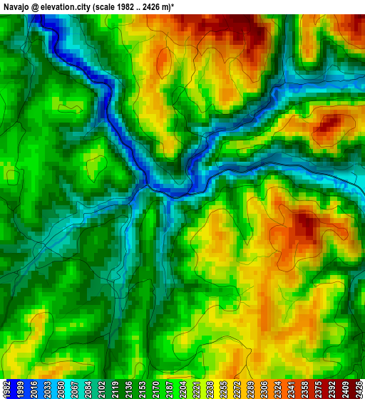
Below is the Elevation map of Navajo, which displays elevation range with different colors. Scale of the first map is from 1982 to 2426 m (6503 to 7959 ft) with average elevation of 2176.2 meters (=7140 ft) [note 1]
These maps also provides idea of topography and contour of this city, they are displayed at different zoom levels. More info about maps, scale and edge coordinates you can find below images.
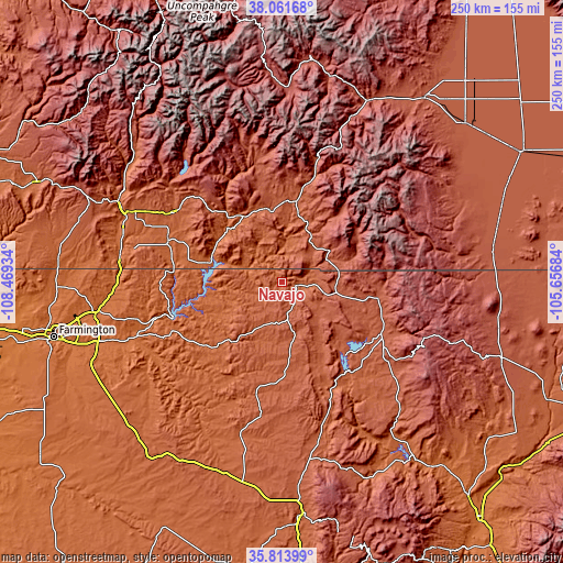
| \ | Map #1 | Topo.Map |
| Scale [m] | 1982..2426 m | × |
| Scale [ft] | 6503..7959 ft | × |
| Average | 2176.2 m = 7140 ft | × |
| Width | 7.81 km = 4.9 mi | 249.9 km = 155.3 mi |
| Height | 7.81 km = 4.9 mi | 249.9 km = 155.3 mi |
| ↑Max Latitude | 36.981233° | 38.06168° |
| Latitude at center | 36.94612° | 36.94612° |
| ↓Min Latitude | 36.910991° | 35.81399° |
| ← Min Longitude | -107.107035° | -108.46934° |
| Longitude center | -107.06309° | -107.06309° |
| →Max Longitude | -107.019145° | -105.65684° |
Nearby cities:
Cities around Navajo sort by population:
• Durango elevation 1998 m
81.2 km,  296°
296°
• Bloomfield 1665 m
86.1 km,  252°
252°
• Aztec 1727 m
83.8 km,  260°
260°
• Lee Acres 1666 m
90.9 km, 252°
• West Hammond 1647 m
92.6 km, 251°
• Dulce 2070 m
5.9 km,  103°
103°
• Bayfield 2108 m
56.7 km, 303°
• Flora Vista 1680 m
92 km, 259°
• Pagosa Springs 2170 m
36.3 km,  7°
7°
• Spencerville 1733 m
89.6 km, 260°
• Chama 2396 m
43.3 km, 96°
• Tierra Amarilla 2295 m
53.2 km,  120°
120°
Multilingual:
 En español:
Navajo elevación 2010 m.
 En France:
Navajo élévation 2010 m.


Sources and notes:
- [note 1] Map square and city borders are not equal. Map elevation data is calculated only from area inside that square.
- [src 1] Elevation data from geonames database provided with same terms of usage.
- [src 2] The elevation map of Navajo is generated using elevation data from NASA's 3 arcsec (90m) resolution SRTM data.
- [src 3] Base (background) map © OpenStreetMap contributors tiles are generated by Geofabrik and OpenTopoMap.
Copyright & License:
This Navajo Elevation Map is licensed under CC BY-SA. You may reuse any part from this page, if you give a proper credit by linking to this URL:
 More info on terms of use page.