Taos elevation
Taos (New Mexico, Taos County), United States elevation is 2123 meters and Taos elevation in feet is 6965 ft above sea level [src 1]. Taos is a seat of a second-order administrative division (feature code) with elevation that is 1844 meters (6050 ft) bigger than average city elevation in United States.
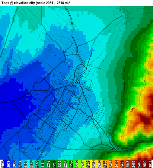
Below is the Elevation map of Taos, which displays elevation range with different colors. Scale of the first map is from 2061 to 2518 m (6762 to 8261 ft) with average elevation of 2157.8 meters (=7079 ft) [note 1]
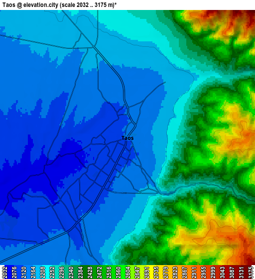
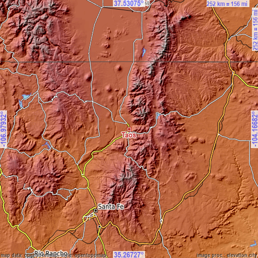
These maps also provides idea of topography and contour of this city, they are displayed at different zoom levels. More info about maps, scale and edge coordinates you can find below images.
| \ | Map #1 | Map #2 | Topo.Map |
| Scale [m] | 2061..2518 m | 2032..3175 m | × |
| Scale [ft] | 6762..8261 ft | 6667..10417 ft | × |
| Average | 2157.8 m = 7079 ft | 2281.2 m = 7484 ft | × |
| Width | 7.87 km = 4.9 mi | 15.73 km = 9.8 mi | 251.7 km = 156.4 mi |
| Height | 7.87 km = 4.9 mi | 15.73 km = 9.8 mi | 251.7 km = 156.4 mi |
| ↑Max Latitude | 36.44261° | 36.477954° | 37.53075° |
| Latitude at center | 36.40725° | 36.40725° | 36.40725° |
| ↓Min Latitude | 36.371874° | 36.336482° | 35.26727° |
| ← Min Longitude | -105.617015° | -105.660961° | -106.97932° |
| Longitude center | -105.57307° | -105.57307° | -105.57307° |
| →Max Longitude | -105.529125° | -105.485179° | -104.16682° |
Nearby cities:
Cities around Taos sort by population:
• Española elevation 1702 m
64.9 km,  224°
224°
• Chimayo 1851 m
56 km, 216°
• Ranchos de Taos 2106 m
6.3 km,  211°
211°
• Arroyo Seco 2328 m
12.2 km,  1°
1°
• Questa 2274 m
33 km,  356°
356°
• El Valle de Arroyo Seco 1746 m
64.2 km, 219°
• La Puebla 1798 m
60 km, 219°
• Ohkay Owingeh 1727 m
59.6 km,  228°
228°
• Taos Pueblo 2172 m
4.3 km,  36°
36°
• Angel Fire 2566 m
25.8 km,  93°
93°
• Santa Clara Pueblo 1706 m
67.5 km, 223°
• Mora 2190 m
52.9 km,  155°
155°
Multilingual:
 En español:
Taos elevación 2123 m.
 En France:
Taos élévation 2123 m.


Sources and notes:
- [note 1] Map square and city borders are not equal. Map elevation data is calculated only from area inside that square.
- [src 1] Elevation data from geonames database provided with same terms of usage.
- [src 2] The elevation map of Taos is generated using elevation data from NASA's 3 arcsec (90m) resolution SRTM data.
- [src 3] Base (background) map © OpenStreetMap contributors tiles are generated by Geofabrik and OpenTopoMap.
Copyright & License:
This Taos Elevation Map is licensed under CC BY-SA. You may reuse any part from this page, if you give a proper credit by linking to this URL:
 More info on terms of use page.