Ohkay Owingeh elevation
Ohkay Owingeh (New Mexico, Rio Arriba County), United States elevation is 1727 meters and Ohkay Owingeh elevation in feet is 5666 ft above sea level [src 1]. Ohkay Owingeh is a populated place (feature code) with elevation that is 1448 meters (4751 ft) bigger than average city elevation in United States.
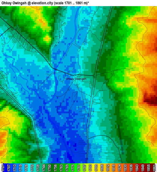
Below is the Elevation map of Ohkay Owingeh, which displays elevation range with different colors. Scale of the first map is from 1701 to 1861 m (5581 to 6106 ft) with average elevation of 1750.4 meters (=5743 ft) [note 1]
These maps also provides idea of topography and contour of this city, they are displayed at different zoom levels. More info about maps, scale and edge coordinates you can find below images.
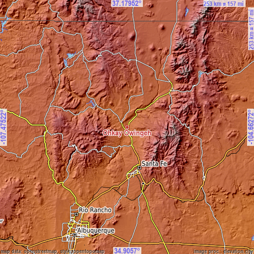
| \ | Map #1 | Topo.Map |
| Scale [m] | 1701..1861 m | × |
| Scale [ft] | 5581..6106 ft | × |
| Average | 1750.4 m = 5743 ft | × |
| Width | 7.9 km = 4.9 mi | 252.8 km = 157.1 mi |
| Height | 7.9 km = 4.9 mi | 252.8 km = 157.1 mi |
| ↑Max Latitude | 36.086342° | 37.17952° |
| Latitude at center | 36.05082° | 36.05082° |
| ↓Min Latitude | 36.015282° | 34.9057° |
| ← Min Longitude | -106.112915° | -107.47522° |
| Longitude center | -106.06897° | -106.06897° |
| →Max Longitude | -106.025025° | -104.66272° |
Nearby cities:
Cities around Ohkay Owingeh sort by population:
• Santa Fe elevation 2137 m
42.1 km,  163°
163°
• Los Alamos 2191 m
28 km,  229°
229°
• Española 1702 m
6.7 km,  188°
188°
• White Rock 1942 m
27.6 km,  206°
206°
• Chimayo 1851 m
12.1 km,  115°
115°
• Pojoaque 1781 m
18 km,  166°
166°
• Nambe 1828 m
19.2 km, 156°
• La Mesilla 1713 m
11.4 km,  180°
180°
• El Valle de Arroyo Seco 1746 m
10.4 km, 160°
• El Rancho 1731 m
18 km, 183°
• La Puebla 1798 m
9.5 km,  136°
136°
• Santa Clara Pueblo 1706 m
9.6 km, 190°
Multilingual:
 En español:
Ohkay Owingeh elevación 1727 m.
 En France:
Ohkay Owingeh élévation 1727 m.
 Auf Deutsch:
Ohkay Owingeh höhe über dem Meeresspiegel ist 1727 m.

Sources and notes:
- [note 1] Map square and city borders are not equal. Map elevation data is calculated only from area inside that square.
- [src 1] Elevation data from geonames database provided with same terms of usage.
- [src 2] The elevation map of Ohkay Owingeh is generated using elevation data from NASA's 3 arcsec (90m) resolution SRTM data.
- [src 3] Base (background) map © OpenStreetMap contributors tiles are generated by Geofabrik and OpenTopoMap.
Copyright & License:
This Ohkay Owingeh Elevation Map is licensed under CC BY-SA. You may reuse any part from this page, if you give a proper credit by linking to this URL:
 More info on terms of use page.