Mayville elevation
Mayville (Wisconsin, Dodge County), United States elevation is 283 meters and Mayville elevation in feet is 928 ft above sea level [src 1]. Mayville is a populated place (feature code) with elevation that is 4 meters (13 ft) bigger than average city elevation in United States.
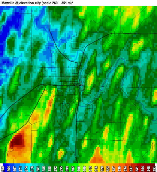
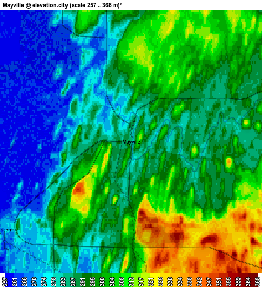
Below is the Elevation map of Mayville, which displays elevation range with different colors. Scale of the first map is from 260 to 351 m (853 to 1152 ft) with average elevation of 291.4 meters (=956 ft) [note 1]
These maps also provides idea of topography and contour of this city, they are displayed at different zoom levels. More info about maps, scale and edge coordinates you can find below images.
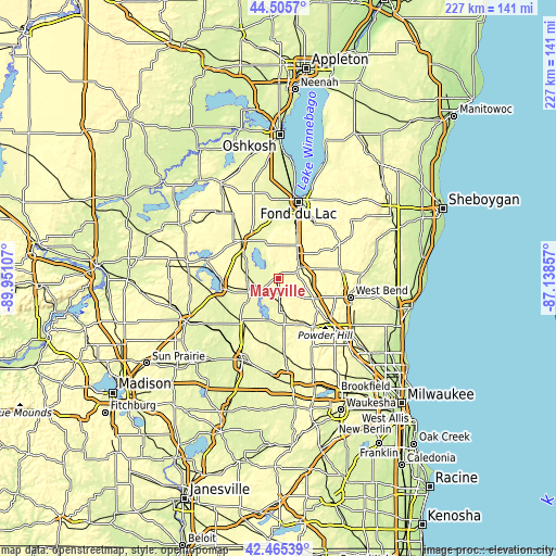
| \ | Map #1 | Map #2 | Topo.Map |
| Scale [m] | 260..351 m | 257..368 m | × |
| Scale [ft] | 853..1152 ft | 843..1207 ft | × |
| Average | 291.4 m = 956 ft | 291.7 m = 957 ft | × |
| Width | 7.09 km = 4.4 mi | 14.18 km = 8.8 mi | 226.9 km = 141 mi |
| Height | 7.09 km = 4.4 mi | 14.18 km = 8.8 mi | 226.9 km = 141 mi |
| ↑Max Latitude | 43.526031° | 43.557886° | 44.5057° |
| Latitude at center | 43.49416° | 43.49416° | 43.49416° |
| ↓Min Latitude | 43.462272° | 43.430367° | 42.46539° |
| ← Min Longitude | -88.588765° | -88.632711° | -89.95107° |
| Longitude center | -88.54482° | -88.54482° | -88.54482° |
| →Max Longitude | -88.500875° | -88.456929° | -87.13857° |
Nearby cities:
Cities around Mayville sort by population:
• Beaver Dam elevation 268 m
23.9 km,  260°
260°
• Hartford 301 m
23.7 km,  145°
145°
• Waupun 276 m
21.5 km,  316°
316°
• Horicon 271 m
8.4 km,  235°
235°
• Addison 320 m
15.9 km,  120°
120°
• Juneau 283 m
16.3 km,  232°
232°
• Lomira 323 m
13.5 km,  37°
37°
• Campbellsport 316 m
24.3 km,  61°
61°
• Ashford 319 m
17.4 km,  53°
53°
• Theresa 292 m
8 km,  71°
71°
• Hustisford 266 m
17.1 km,  195°
195°
• Oakfield 274 m
21.3 km,  359°
359°
Multilingual:
 En español:
Mayville elevación 283 m.
 En France:
Mayville élévation 283 m.
 Auf Deutsch:
Mayville höhe über dem Meeresspiegel ist 283 m.

Sources and notes:
- [note 1] Map square and city borders are not equal. Map elevation data is calculated only from area inside that square.
- [src 1] Elevation data from geonames database provided with same terms of usage.
- [src 2] The elevation map of Mayville is generated using elevation data from NASA's 3 arcsec (90m) resolution SRTM data.
- [src 3] Base (background) map © OpenStreetMap contributors tiles are generated by Geofabrik and OpenTopoMap.
Copyright & License:
This Mayville Elevation Map is licensed under CC BY-SA. You may reuse any part from this page, if you give a proper credit by linking to this URL:
 More info on terms of use page.