Waupun elevation
Waupun (Wisconsin, Dodge County), United States elevation is 276 meters and Waupun elevation in feet is 906 ft above sea level [src 1]. Waupun is a populated place (feature code) with elevation that is 3 meters (10 ft) smaller than average city elevation in United States.
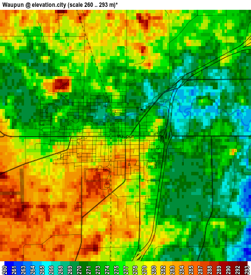
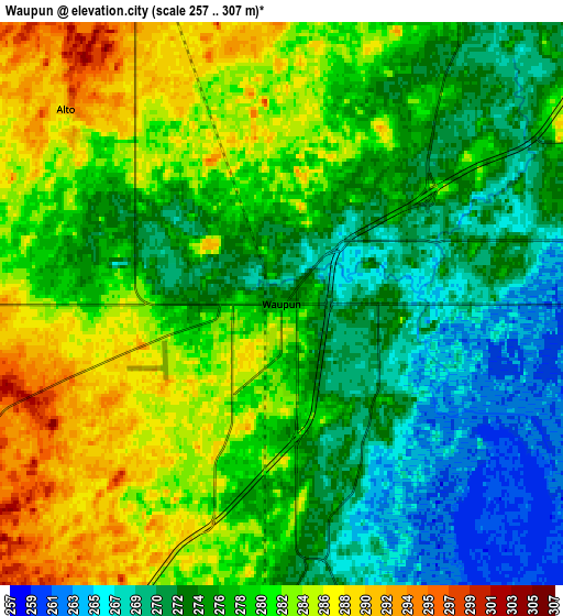
Below is the Elevation map of Waupun, which displays elevation range with different colors. Scale of the first map is from 260 to 293 m (853 to 961 ft) with average elevation of 276.1 meters (=906 ft) [note 1]
These maps also provides idea of topography and contour of this city, they are displayed at different zoom levels. More info about maps, scale and edge coordinates you can find below images.
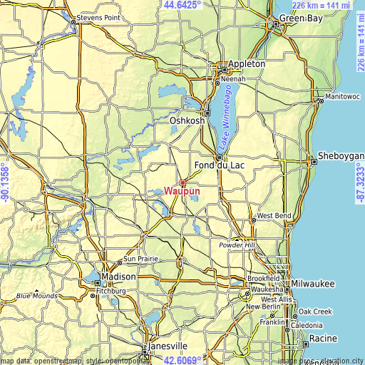
| \ | Map #1 | Map #2 | Topo.Map |
| Scale [m] | 260..293 m | 257..307 m | × |
| Scale [ft] | 853..961 ft | 843..1007 ft | × |
| Average | 276.1 m = 906 ft | 277.6 m = 911 ft | × |
| Width | 7.07 km = 4.4 mi | 14.15 km = 8.8 mi | 226.3 km = 140.6 mi |
| Height | 7.07 km = 4.4 mi | 14.15 km = 8.8 mi | 226.3 km = 140.6 mi |
| ↑Max Latitude | 43.665118° | 43.696899° | 44.6425° |
| Latitude at center | 43.63332° | 43.63332° | 43.63332° |
| ↓Min Latitude | 43.601505° | 43.569674° | 42.6069° |
| ← Min Longitude | -88.773495° | -88.817441° | -90.1358° |
| Longitude center | -88.72955° | -88.72955° | -88.72955° |
| →Max Longitude | -88.685605° | -88.641659° | -87.3233° |
Nearby cities:
Cities around Waupun sort by population:
• Beaver Dam elevation 268 m
21.4 km,  203°
203°
• Mayville 283 m
21.5 km,  136°
136°
• Horicon 271 m
21.7 km,  158°
158°
• Lomira 323 m
23.5 km,  101°
101°
• Randolph 296 m
24.7 km,  244°
244°
• Lamartine 269 m
17.1 km,  49°
49°
• Fox Lake 281 m
16.1 km, 242°
• Eldorado 271 m
23 km,  22°
22°
• Markesan 264 m
22.5 km,  291°
291°
• Oakfield 274 m
15.9 km,  68°
68°
• Alto 294 m
7.1 km,  312°
312°
• Rosendale 275 m
19.9 km,  12°
12°
Multilingual:
 En español:
Waupun elevación 276 m.
 En France:
Waupun élévation 276 m.


Sources and notes:
- [note 1] Map square and city borders are not equal. Map elevation data is calculated only from area inside that square.
- [src 1] Elevation data from geonames database provided with same terms of usage.
- [src 2] The elevation map of Waupun is generated using elevation data from NASA's 3 arcsec (90m) resolution SRTM data.
- [src 3] Base (background) map © OpenStreetMap contributors tiles are generated by Geofabrik and OpenTopoMap.
Copyright & License:
This Waupun Elevation Map is licensed under CC BY-SA. You may reuse any part from this page, if you give a proper credit by linking to this URL:
 More info on terms of use page.