Randolph elevation
Randolph (Wisconsin, Dodge County), United States elevation is 296 meters and Randolph elevation in feet is 971 ft above sea level [src 1]. Randolph is a populated place (feature code) with elevation that is 17 meters (56 ft) bigger than average city elevation in United States.
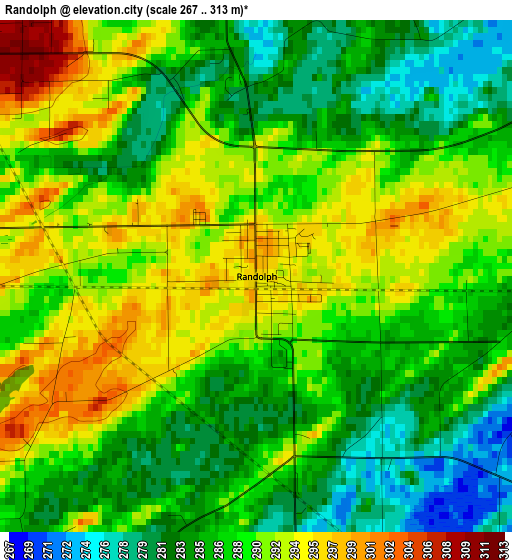
Below is the Elevation map of Randolph, which displays elevation range with different colors. Scale of the first map is from 267 to 313 m (876 to 1027 ft) with average elevation of 288.1 meters (=945 ft) [note 1]
These maps also provides idea of topography and contour of this city, they are displayed at different zoom levels. More info about maps, scale and edge coordinates you can find below images.
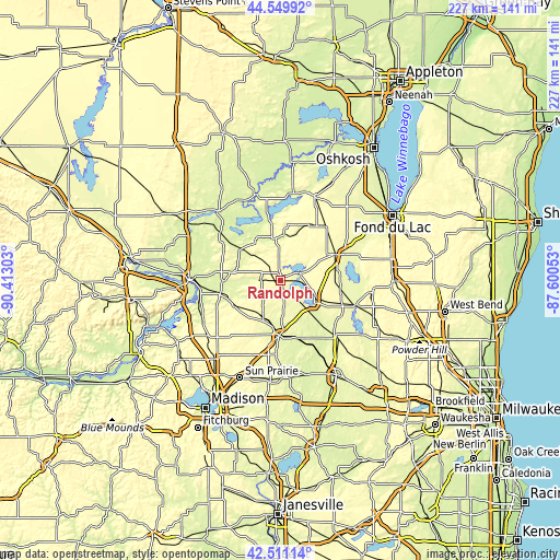
| \ | Map #1 | Topo.Map |
| Scale [m] | 267..313 m | × |
| Scale [ft] | 876..1027 ft | × |
| Average | 288.1 m = 945 ft | × |
| Width | 7.08 km = 4.4 mi | 226.7 km = 140.9 mi |
| Height | 7.08 km = 4.4 mi | 226.7 km = 140.9 mi |
| ↑Max Latitude | 43.570998° | 44.54992° |
| Latitude at center | 43.53915° | 43.53915° |
| ↓Min Latitude | 43.507285° | 42.51114° |
| ← Min Longitude | -89.050725° | -90.41303° |
| Longitude center | -89.00678° | -89.00678° |
| →Max Longitude | -88.962835° | -87.60053° |
Nearby cities:
Cities around Randolph sort by population:
• Beaver Dam elevation 268 m
16.4 km,  123°
123°
• Waupun 276 m
24.7 km,  64°
64°
• Columbus 261 m
22.4 km,  181°
181°
• Horicon 271 m
31.8 km,  107°
107°
• Juneau 283 m
28.5 km, 121°
• Pardeeville 251 m
23.6 km,  269°
269°
• Fall River 265 m
17.5 km,  190°
190°
• Fox Lake 281 m
8.6 km,  70°
70°
• Markesan 264 m
18.7 km,  4°
4°
• Alto 294 m
22.9 km,  48°
48°
• Rio 289 m
21.4 km,  241°
241°
• Manchester 271 m
17.2 km,  348°
348°
Multilingual:
 En español:
Randolph elevación 296 m.
 En France:
Randolph élévation 296 m.
 Auf Deutsch:
Randolph höhe über dem Meeresspiegel ist 296 m.

Sources and notes:
- [note 1] Map square and city borders are not equal. Map elevation data is calculated only from area inside that square.
- [src 1] Elevation data from geonames database provided with same terms of usage.
- [src 2] The elevation map of Randolph is generated using elevation data from NASA's 3 arcsec (90m) resolution SRTM data.
- [src 3] Base (background) map © OpenStreetMap contributors tiles are generated by Geofabrik and OpenTopoMap.
Copyright & License:
This Randolph Elevation Map is licensed under CC BY-SA. You may reuse any part from this page, if you give a proper credit by linking to this URL:
 More info on terms of use page.