Fall River elevation
Fall River (Wisconsin, Columbia County), United States elevation is 265 meters and Fall River elevation in feet is 869 ft above sea level [src 1]. Fall River is a populated place (feature code) with elevation that is 14 meters (46 ft) smaller than average city elevation in United States.
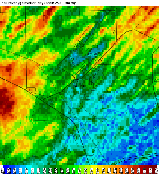
Below is the Elevation map of Fall River, which displays elevation range with different colors. Scale of the first map is from 250 to 294 m (820 to 965 ft) with average elevation of 268.1 meters (=880 ft) [note 1]
These maps also provides idea of topography and contour of this city, they are displayed at different zoom levels. More info about maps, scale and edge coordinates you can find below images.
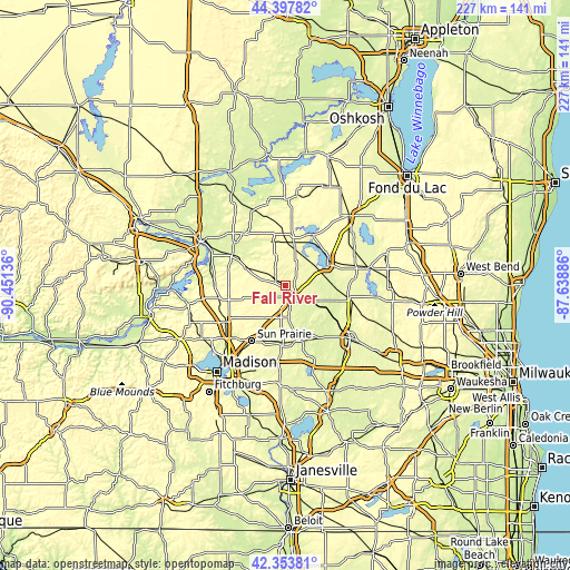
| \ | Map #1 | Topo.Map |
| Scale [m] | 250..294 m | × |
| Scale [ft] | 820..965 ft | × |
| Average | 268.1 m = 880 ft | × |
| Width | 7.1 km = 4.4 mi | 227.3 km = 141.2 mi |
| Height | 7.1 km = 4.4 mi | 227.3 km = 141.2 mi |
| ↑Max Latitude | 43.416359° | 44.39782° |
| Latitude at center | 43.38443° | 43.38443° |
| ↓Min Latitude | 43.352484° | 42.35381° |
| ← Min Longitude | -89.089055° | -90.45136° |
| Longitude center | -89.04511° | -89.04511° |
| →Max Longitude | -89.001165° | -87.63886° |
Nearby cities:
Cities around Fall River sort by population:
• Sun Prairie elevation 291 m
26.2 km,  211°
211°
• Beaver Dam 268 m
18.7 km,  64°
64°
• De Forest 290 m
28.5 km,  237°
237°
• Columbus 261 m
5.7 km,  155°
155°
• Marshall 268 m
24.1 km,  184°
184°
• Waterloo 249 m
22.8 km,  168°
168°
• Juneau 283 m
27.6 km,  85°
85°
• Poynette 258 m
28.9 km,  271°
271°
• Pardeeville 251 m
26.7 km,  309°
309°
• Randolph 296 m
17.5 km,  10°
10°
• Fox Lake 281 m
23 km,  29°
29°
• Rio 289 m
17.2 km,  294°
294°
Multilingual:
 En español:
Fall River elevación 265 m.
 En France:
Fall River élévation 265 m.
 Auf Deutsch:
Fall River höhe über dem Meeresspiegel ist 265 m.

Sources and notes:
- [note 1] Map square and city borders are not equal. Map elevation data is calculated only from area inside that square.
- [src 1] Elevation data from geonames database provided with same terms of usage.
- [src 2] The elevation map of Fall River is generated using elevation data from NASA's 3 arcsec (90m) resolution SRTM data.
- [src 3] Base (background) map © OpenStreetMap contributors tiles are generated by Geofabrik and OpenTopoMap.
Copyright & License:
This Fall River Elevation Map is licensed under CC BY-SA. You may reuse any part from this page, if you give a proper credit by linking to this URL:
 More info on terms of use page.