Lomira elevation
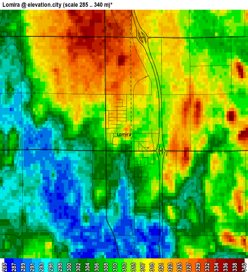
Lomira (Wisconsin, Dodge County), United States elevation is 323 meters and Lomira elevation in feet is 1060 ft above sea level [src 1]. Lomira is a populated place (feature code) with elevation that is 44 meters (144 ft) bigger than average city elevation in United States.
Below is the Elevation map of Lomira, which displays elevation range with different colors. Scale of the first map is from 285 to 340 m (935 to 1115 ft) with average elevation of 309.5 meters (=1015 ft) [note 1]
These maps also provides idea of topography and contour of this city, they are displayed at different zoom levels. More info about maps, scale and edge coordinates you can find below images.
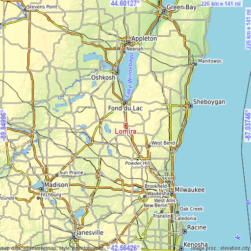
| \ | Map #1 | Topo.Map |
| Scale [m] | 285..340 m | × |
| Scale [ft] | 935..1115 ft | × |
| Average | 309.5 m = 1015 ft | × |
| Width | 7.08 km = 4.4 mi | 226.5 km = 140.7 mi |
| Height | 7.08 km = 4.4 mi | 226.5 km = 140.7 mi |
| ↑Max Latitude | 43.6232° | 44.60127° |
| Latitude at center | 43.59138° | 43.59138° |
| ↓Min Latitude | 43.559543° | 42.56426° |
| ← Min Longitude | -88.487655° | -89.84996° |
| Longitude center | -88.44371° | -88.44371° |
| →Max Longitude | -88.399765° | -87.03746° |
Nearby cities:
Cities around Lomira sort by population:
• Fond du Lac elevation 234 m
20.4 km,  1°
1°
• Waupun 276 m
23.5 km,  281°
281°
• North Fond du Lac 233 m
24.7 km,  352°
352°
• Mayville 283 m
13.5 km,  217°
217°
• Kewaskum 291 m
19 km,  114°
114°
• Horicon 271 m
21.7 km, 224°
• Addison 320 m
19.6 km,  163°
163°
• Campbellsport 316 m
13.3 km,  86°
86°
• Lamartine 269 m
18.7 km,  327°
327°
• Ashford 319 m
5.9 km, 94°
• Theresa 292 m
8.3 km,  184°
184°
• Oakfield 274 m
13.4 km,  321°
321°
Multilingual:
 En español:
Lomira elevación 323 m.
 En France:
Lomira élévation 323 m.


Sources and notes:
- [note 1] Map square and city borders are not equal. Map elevation data is calculated only from area inside that square.
- [src 1] Elevation data from geonames database provided with same terms of usage.
- [src 2] The elevation map of Lomira is generated using elevation data from NASA's 3 arcsec (90m) resolution SRTM data.
- [src 3] Base (background) map © OpenStreetMap contributors tiles are generated by Geofabrik and OpenTopoMap.
Copyright & License:
This Lomira Elevation Map is licensed under CC BY-SA. You may reuse any part from this page, if you give a proper credit by linking to this URL:
 More info on terms of use page.