Hartford elevation
Hartford (Wisconsin, Washington County), United States elevation is 301 meters and Hartford elevation in feet is 988 ft above sea level [src 1]. Hartford is a populated place (feature code) with elevation that is 22 meters (72 ft) bigger than average city elevation in United States.
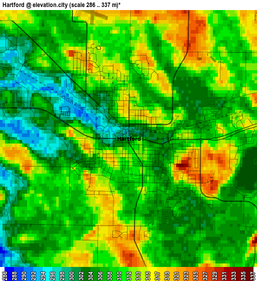
Below is the Elevation map of Hartford, which displays elevation range with different colors. Scale of the first map is from 286 to 337 m (938 to 1106 ft) with average elevation of 308.7 meters (=1013 ft) [note 1]
These maps also provides idea of topography and contour of this city, they are displayed at different zoom levels. More info about maps, scale and edge coordinates you can find below images.
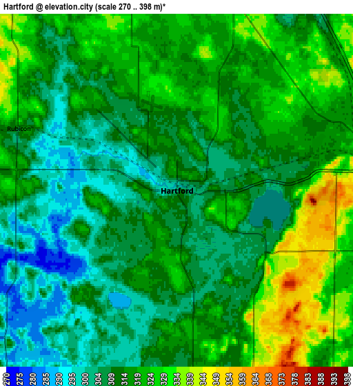
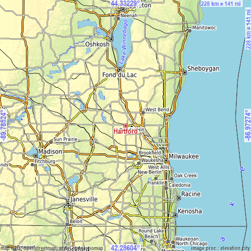
| \ | Map #1 | Map #2 | Topo.Map |
| Scale [m] | 286..337 m | 270..398 m | × |
| Scale [ft] | 938..1106 ft | 886..1306 ft | × |
| Average | 308.7 m = 1013 ft | 314.9 m = 1033 ft | × |
| Width | 7.11 km = 4.4 mi | 14.22 km = 8.8 mi | 227.5 km = 141.4 mi |
| Height | 7.11 km = 4.4 mi | 14.22 km = 8.8 mi | 227.5 km = 141.4 mi |
| ↑Max Latitude | 43.349744° | 43.381692° | 44.33229° |
| Latitude at center | 43.31778° | 43.31778° | 43.31778° |
| ↓Min Latitude | 43.285799° | 43.253801° | 42.28604° |
| ← Min Longitude | -88.422935° | -88.466881° | -89.78524° |
| Longitude center | -88.37899° | -88.37899° | -88.37899° |
| →Max Longitude | -88.335045° | -88.291099° | -86.97274° |
Nearby cities:
Cities around Hartford sort by population:
• West Bend elevation 277 m
19.8 km,  52°
52°
• Richfield 301 m
16.5 km,  114°
114°
• Hartland 289 m
23.8 km,  172°
172°
• Jackson 275 m
17.2 km,  87°
87°
• Slinger 330 m
7.7 km,  76°
76°
• Mayville 283 m
23.7 km,  325°
325°
• Okauchee Lake 267 m
22.2 km,  193°
193°
• Merton 299 m
19.9 km,  162°
162°
• Addison 320 m
11.7 km,  1°
1°
• Barton 282 m
21.3 km, 48°
• Theresa 292 m
22.9 km,  345°
345°
• Hustisford 266 m
18.2 km,  279°
279°
Multilingual:
 En español:
Hartford elevación 301 m.
 En France:
Hartford élévation 301 m.
 Auf Deutsch:
Hartford höhe über dem Meeresspiegel ist 301 m.

Sources and notes:
- [note 1] Map square and city borders are not equal. Map elevation data is calculated only from area inside that square.
- [src 1] Elevation data from geonames database provided with same terms of usage.
- [src 2] The elevation map of Hartford is generated using elevation data from NASA's 3 arcsec (90m) resolution SRTM data.
- [src 3] Base (background) map © OpenStreetMap contributors tiles are generated by Geofabrik and OpenTopoMap.
Copyright & License:
This Hartford Elevation Map is licensed under CC BY-SA. You may reuse any part from this page, if you give a proper credit by linking to this URL:
 More info on terms of use page.