Canfield elevation
Canfield (Ohio, Mahoning County), United States elevation is 353 meters and Canfield elevation in feet is 1158 ft above sea level [src 1]. Canfield is a populated place (feature code) with elevation that is 74 meters (243 ft) bigger than average city elevation in United States.
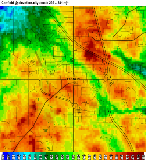
Below is the Elevation map of Canfield, which displays elevation range with different colors. Scale of the first map is from 292 to 381 m (958 to 1250 ft) with average elevation of 346.2 meters (=1136 ft) [note 1]
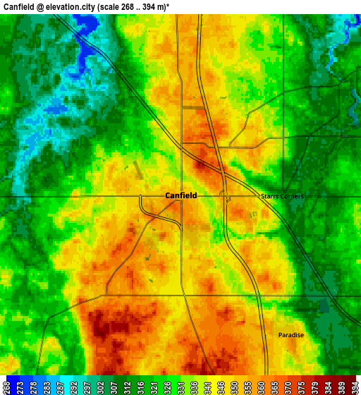
These maps also provides idea of topography and contour of this city, they are displayed at different zoom levels. More info about maps, scale and edge coordinates you can find below images.
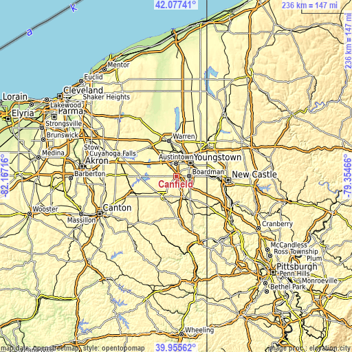
| \ | Map #1 | Map #2 | Topo.Map |
| Scale [m] | 292..381 m | 268..394 m | × |
| Scale [ft] | 958..1250 ft | 879..1293 ft | × |
| Average | 346.2 m = 1136 ft | 331.7 m = 1088 ft | × |
| Width | 7.37 km = 4.6 mi | 14.75 km = 9.2 mi | 235.9 km = 146.6 mi |
| Height | 7.37 km = 4.6 mi | 14.75 km = 9.2 mi | 235.9 km = 146.6 mi |
| ↑Max Latitude | 41.058205° | 41.091333° | 42.07741° |
| Latitude at center | 41.02506° | 41.02506° | 41.02506° |
| ↓Min Latitude | 40.991898° | 40.95872° | 39.95562° |
| ← Min Longitude | -80.804855° | -80.848801° | -82.16716° |
| Longitude center | -80.76091° | -80.76091° | -80.76091° |
| →Max Longitude | -80.716965° | -80.673019° | -79.35466° |
Nearby cities:
Cities around Canfield sort by population:
• Youngstown elevation 267 m
12.5 km,  48°
48°
• Boardman 336 m
8.2 km,  90°
90°
• Austintown 345 m
8.5 km,  357°
357°
• Salem 374 m
16 km,  210°
210°
• Struthers 307 m
13.2 km,  76°
76°
• Girard 277 m
15.2 km,  19°
19°
• Campbell 316 m
14.8 km,  66°
66°
• Columbiana 350 m
16.2 km,  159°
159°
• Mineral Ridge 308 m
12.8 km, 356°
• McDonald 293 m
15.7 km,  11°
11°
• Poland 316 m
12.3 km, 90°
• Leetonia 310 m
16.4 km,  178°
178°
Multilingual:
 En español:
Canfield elevación 353 m.
 En France:
Canfield élévation 353 m.
 Auf Deutsch:
Canfield höhe über dem Meeresspiegel ist 353 m.

Sources and notes:
- [note 1] Map square and city borders are not equal. Map elevation data is calculated only from area inside that square.
- [src 1] Elevation data from geonames database provided with same terms of usage.
- [src 2] The elevation map of Canfield is generated using elevation data from NASA's 3 arcsec (90m) resolution SRTM data.
- [src 3] Base (background) map © OpenStreetMap contributors tiles are generated by Geofabrik and OpenTopoMap.
Copyright & License:
This Canfield Elevation Map is licensed under CC BY-SA. You may reuse any part from this page, if you give a proper credit by linking to this URL:
 More info on terms of use page.