Youngstown elevation
Youngstown (Ohio, Mahoning County), United States elevation is 267 meters and Youngstown elevation in feet is 876 ft above sea level [src 1]. Youngstown is a seat of a second-order administrative division (feature code) with elevation that is 12 meters (39 ft) smaller than average city elevation in United States.
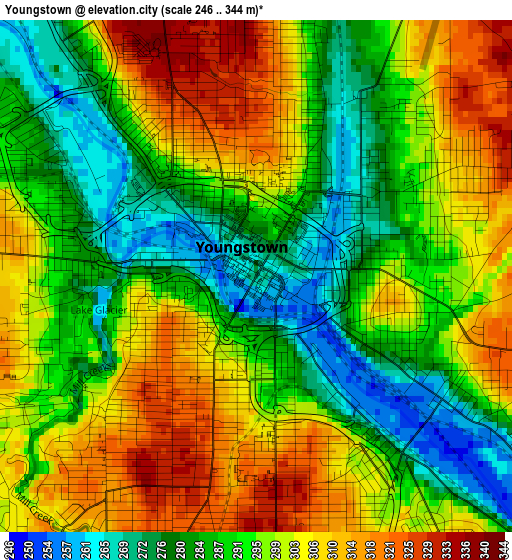
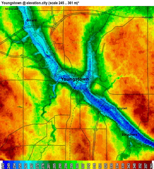
Below is the Elevation map of Youngstown, which displays elevation range with different colors. Scale of the first map is from 246 to 344 m (807 to 1129 ft) with average elevation of 295.2 meters (=969 ft) [note 1]
These maps also provides idea of topography and contour of this city, they are displayed at different zoom levels. More info about maps, scale and edge coordinates you can find below images.
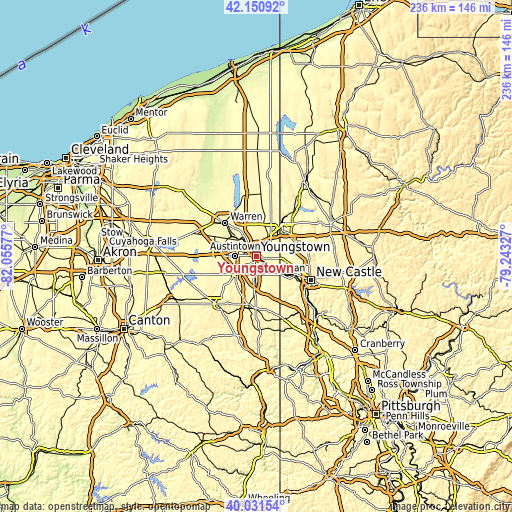
| \ | Map #1 | Map #2 | Topo.Map |
| Scale [m] | 246..344 m | 245..361 m | × |
| Scale [ft] | 807..1129 ft | 804..1184 ft | × |
| Average | 295.2 m = 969 ft | 311.6 m = 1022 ft | × |
| Width | 7.36 km = 4.6 mi | 14.73 km = 9.2 mi | 235.7 km = 146.5 mi |
| Height | 7.36 km = 4.6 mi | 14.73 km = 9.2 mi | 235.6 km = 146.4 mi |
| ↑Max Latitude | 41.132887° | 41.165978° | 42.15092° |
| Latitude at center | 41.09978° | 41.09978° | 41.09978° |
| ↓Min Latitude | 41.066656° | 41.033515° | 40.03154° |
| ← Min Longitude | -80.693465° | -80.737411° | -82.05577° |
| Longitude center | -80.64952° | -80.64952° | -80.64952° |
| →Max Longitude | -80.605575° | -80.561629° | -79.24327° |
Nearby cities:
Cities around Youngstown sort by population:
• Boardman elevation 336 m
8.5 km,  187°
187°
• Austintown 345 m
9.6 km,  271°
271°
• Struthers 307 m
6.3 km,  146°
146°
• Girard 277 m
7.4 km,  324°
324°
• Campbell 316 m
4.8 km,  119°
119°
• Hubbard 299 m
9.2 km,  46°
46°
• Mineral Ridge 308 m
11 km,  294°
294°
• McDonald 293 m
9.5 km, 318°
• Poland 316 m
8.9 km,  160°
160°
• Churchill 325 m
7 km,  349°
349°
• Lowellville 252 m
11.9 km,  127°
127°
• McKinley Heights 300 m
10.9 km,  328°
328°
Multilingual:
 En español:
Youngstown elevación 267 m.
 En France:
Youngstown élévation 267 m.
 Auf Deutsch:
Youngstown höhe über dem Meeresspiegel ist 267 m.

Sources and notes:
- [note 1] Map square and city borders are not equal. Map elevation data is calculated only from area inside that square.
- [src 1] Elevation data from geonames database provided with same terms of usage.
- [src 2] The elevation map of Youngstown is generated using elevation data from NASA's 3 arcsec (90m) resolution SRTM data.
- [src 3] Base (background) map © OpenStreetMap contributors tiles are generated by Geofabrik and OpenTopoMap.
Copyright & License:
This Youngstown Elevation Map is licensed under CC BY-SA. You may reuse any part from this page, if you give a proper credit by linking to this URL:
 More info on terms of use page.