Girard elevation
Girard (Ohio, Trumbull County), United States elevation is 277 meters and Girard elevation in feet is 909 ft above sea level [src 1]. Girard is a populated place (feature code) with elevation that is 2 meters (7 ft) smaller than average city elevation in United States.
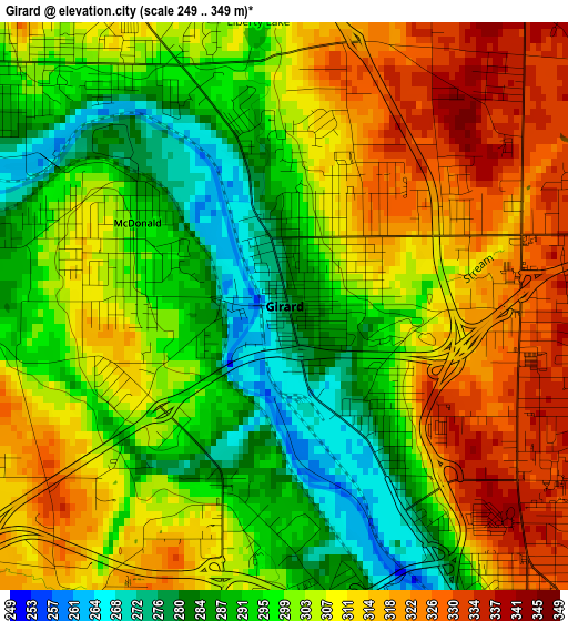
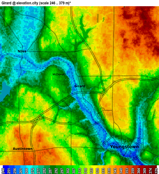
Below is the Elevation map of Girard, which displays elevation range with different colors. Scale of the first map is from 249 to 349 m (817 to 1145 ft) with average elevation of 303.4 meters (=995 ft) [note 1]
These maps also provides idea of topography and contour of this city, they are displayed at different zoom levels. More info about maps, scale and edge coordinates you can find below images.
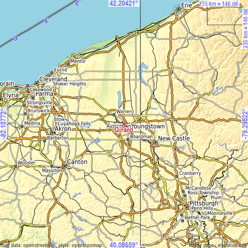
| \ | Map #1 | Map #2 | Topo.Map |
| Scale [m] | 249..349 m | 246..379 m | × |
| Scale [ft] | 817..1145 ft | 807..1243 ft | × |
| Average | 303.4 m = 995 ft | 309.3 m = 1015 ft | × |
| Width | 7.36 km = 4.6 mi | 14.72 km = 9.1 mi | 235.5 km = 146.3 mi |
| Height | 7.36 km = 4.6 mi | 14.72 km = 9.1 mi | 235.5 km = 146.3 mi |
| ↑Max Latitude | 41.18703° | 41.220093° | 42.20421° |
| Latitude at center | 41.15395° | 41.15395° | 41.15395° |
| ↓Min Latitude | 41.120853° | 41.08774° | 40.08659° |
| ← Min Longitude | -80.745415° | -80.789361° | -82.10772° |
| Longitude center | -80.70147° | -80.70147° | -80.70147° |
| →Max Longitude | -80.657525° | -80.613579° | -79.29522° |
Nearby cities:
Cities around Girard sort by population:
• Youngstown elevation 267 m
7.4 km,  144°
144°
• Austintown 345 m
7.8 km,  222°
222°
• Niles 271 m
6.2 km,  300°
300°
• Campbell 316 m
12 km,  134°
134°
• Hubbard 299 m
11.1 km,  88°
88°
• Howland Center 271 m
11.4 km,  341°
341°
• Mineral Ridge 308 m
5.9 km,  254°
254°
• Lordstown 291 m
13.1 km,  275°
275°
• McDonald 293 m
2.2 km, 299°
• Churchill 325 m
3.2 km,  73°
73°
• Bolindale 292 m
8.7 km,  312°
312°
• McKinley Heights 300 m
3.6 km, 338°
Multilingual:
 En español:
Girard elevación 277 m.
 En France:
Girard élévation 277 m.


Sources and notes:
- [note 1] Map square and city borders are not equal. Map elevation data is calculated only from area inside that square.
- [src 1] Elevation data from geonames database provided with same terms of usage.
- [src 2] The elevation map of Girard is generated using elevation data from NASA's 3 arcsec (90m) resolution SRTM data.
- [src 3] Base (background) map © OpenStreetMap contributors tiles are generated by Geofabrik and OpenTopoMap.
Copyright & License:
This Girard Elevation Map is licensed under CC BY-SA. You may reuse any part from this page, if you give a proper credit by linking to this URL:
 More info on terms of use page.