Salem elevation
Salem (Ohio, Columbiana County), United States elevation is 374 meters and Salem elevation in feet is 1227 ft above sea level [src 1]. Salem is a populated place (feature code) with elevation that is 95 meters (312 ft) bigger than average city elevation in United States.
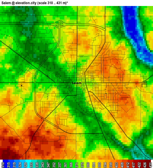
Below is the Elevation map of Salem, which displays elevation range with different colors. Scale of the first map is from 310 to 431 m (1017 to 1414 ft) with average elevation of 375.6 meters (=1232 ft) [note 1]
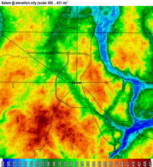
These maps also provides idea of topography and contour of this city, they are displayed at different zoom levels. More info about maps, scale and edge coordinates you can find below images.
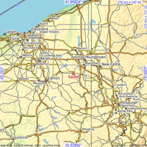
| \ | Map #1 | Map #2 | Topo.Map |
| Scale [m] | 310..431 m | 300..431 m | × |
| Scale [ft] | 1017..1414 ft | 984..1414 ft | × |
| Average | 375.6 m = 1232 ft | 370.8 m = 1217 ft | × |
| Width | 7.39 km = 4.6 mi | 14.77 km = 9.2 mi | 236.4 km = 146.9 mi |
| Height | 7.39 km = 4.6 mi | 14.77 km = 9.2 mi | 236.4 km = 146.9 mi |
| ↑Max Latitude | 40.934097° | 40.967288° | 41.95524° |
| Latitude at center | 40.90089° | 40.90089° | 40.90089° |
| ↓Min Latitude | 40.867666° | 40.834425° | 39.82946° |
| ← Min Longitude | -80.900695° | -80.944641° | -82.263° |
| Longitude center | -80.85675° | -80.85675° | -80.85675° |
| →Max Longitude | -80.812805° | -80.768859° | -79.4505° |
Nearby cities:
Cities around Salem sort by population:
• Boardman elevation 336 m
21.3 km,  49°
49°
• Austintown 345 m
23.6 km,  19°
19°
• Alliance 354 m
21 km,  274°
274°
• Canfield 353 m
16 km,  30°
30°
• Columbiana 350 m
13.8 km,  95°
95°
• Sebring 335 m
13.8 km,  280°
280°
• Lisbon 295 m
16.2 km,  152°
152°
• Poland 316 m
24.5 km,  55°
55°
• Leetonia 310 m
8.9 km,  107°
107°
• New Middletown 381 m
26 km,  75°
75°
• New Waterford 318 m
21.3 km, 106°
• Craig Beach 290 m
26.3 km,  336°
336°
Multilingual:
 En español:
Salem elevación 374 m.
 En France:
Salem élévation 374 m.


Sources and notes:
- [note 1] Map square and city borders are not equal. Map elevation data is calculated only from area inside that square.
- [src 1] Elevation data from geonames database provided with same terms of usage.
- [src 2] The elevation map of Salem is generated using elevation data from NASA's 3 arcsec (90m) resolution SRTM data.
- [src 3] Base (background) map © OpenStreetMap contributors tiles are generated by Geofabrik and OpenTopoMap.
Copyright & License:
This Salem Elevation Map is licensed under CC BY-SA. You may reuse any part from this page, if you give a proper credit by linking to this URL:
 More info on terms of use page.