New Waterford elevation
New Waterford (Ohio, Columbiana County), United States elevation is 318 meters and New Waterford elevation in feet is 1043 ft above sea level [src 1]. New Waterford is a populated place (feature code) with elevation that is 39 meters (128 ft) bigger than average city elevation in United States.
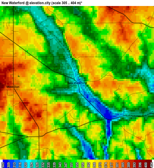
Below is the Elevation map of New Waterford, which displays elevation range with different colors. Scale of the first map is from 305 to 404 m (1001 to 1325 ft) with average elevation of 356.1 meters (=1168 ft) [note 1]
These maps also provides idea of topography and contour of this city, they are displayed at different zoom levels. More info about maps, scale and edge coordinates you can find below images.
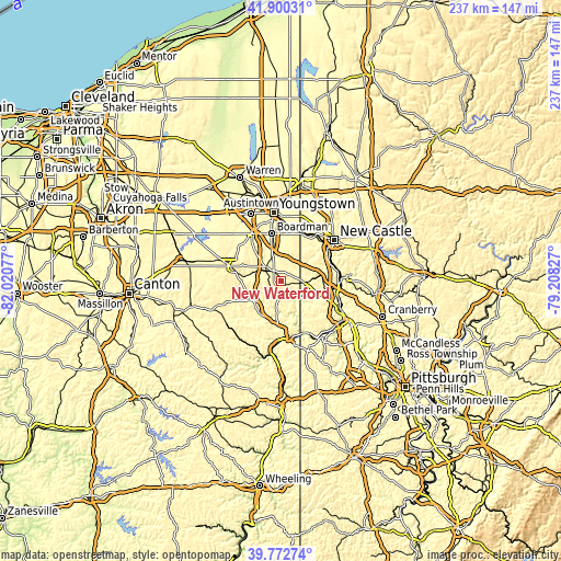
| \ | Map #1 | Topo.Map |
| Scale [m] | 305..404 m | × |
| Scale [ft] | 1001..1325 ft | × |
| Average | 356.1 m = 1168 ft | × |
| Width | 7.39 km = 4.6 mi | 236.6 km = 147 mi |
| Height | 7.39 km = 4.6 mi | 236.6 km = 147 mi |
| ↑Max Latitude | 40.878295° | 41.90031° |
| Latitude at center | 40.84506° | 40.84506° |
| ↓Min Latitude | 40.811808° | 39.77274° |
| ← Min Longitude | -80.658465° | -82.02077° |
| Longitude center | -80.61452° | -80.61452° |
| →Max Longitude | -80.570575° | -79.20827° |
Nearby cities:
Cities around New Waterford sort by population:
• Boardman elevation 336 m
20.3 km,  348°
348°
• Columbiana 350 m
8.2 km,  305°
305°
• East Palestine 305 m
6.4 km,  101°
101°
• Calcutta 339 m
19.4 km,  170°
170°
• Ohioville 339 m
21 km,  151°
151°
• Lisbon 295 m
15.3 km,  237°
237°
• Poland 316 m
19.9 km,  359°
359°
• Glenmoor 346 m
19.9 km,  182°
182°
• Leetonia 310 m
12.4 km,  286°
286°
• New Middletown 381 m
13.8 km,  20°
20°
• New Beaver 375 m
20.8 km,  80°
80°
• Bessemer 331 m
17.6 km,  35°
35°
Multilingual:
 En español:
New Waterford elevación 318 m.
 En France:
New Waterford élévation 318 m.
 Auf Deutsch:
New Waterford höhe über dem Meeresspiegel ist 318 m.

Sources and notes:
- [note 1] Map square and city borders are not equal. Map elevation data is calculated only from area inside that square.
- [src 1] Elevation data from geonames database provided with same terms of usage.
- [src 2] The elevation map of New Waterford is generated using elevation data from NASA's 3 arcsec (90m) resolution SRTM data.
- [src 3] Base (background) map © OpenStreetMap contributors tiles are generated by Geofabrik and OpenTopoMap.
Copyright & License:
This New Waterford Elevation Map is licensed under CC BY-SA. You may reuse any part from this page, if you give a proper credit by linking to this URL:
 More info on terms of use page.